IMAGES TAKEN NEAR TO
Ash Priors, TAUNTON, TA4 3ND
Introduction
This page details the photographs taken nearby to TA4 3ND by members of the Geograph project.
The Geograph project started in 2005 with the aim of publishing, organising and preserving representative images for every square kilometre of Great Britain, Ireland and the Isle of Man.

There are currently over 7.5m images from over14,400 individuals and you can help contribute to the project by visiting https://www.geograph.org.uk
Image Map
Images are licensed for reuse under creativecommons.org/licenses/by-sa/2.0
Notes
- Clicking on the map will re-center to the selected point.
- The higher the marker number, the further away the image location is from the centre of the postcode.
Image Listing (46 Images Found)
Images are licensed for reuse under creativecommons.org/licenses/by-sa/2.0
Image
Details
Distance
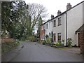
3
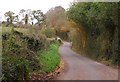
Ash Priors Common
This road junction is at the northwest corner of the common, with roads leading to Northway (left) and Combe Florey. On the right are farmbuildings at the Old Farm House.
Image: © Derek Harper
Taken: 19 Nov 2009
0.06 miles
4

Fumitory, Ash Priors
It may be past mid-November, but there were plenty of flowers on a specimen of Fumaria officinalis by the gate shown in Image
Image: © Derek Harper
Taken: 19 Nov 2009
0.10 miles
5
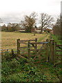
Footpath, Ash Priors
Footpath T1/11 passes through this gate and crosses the side of the field to reach the main village street.
Image: © Derek Harper
Taken: 19 Nov 2009
0.10 miles
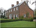
6
Former Inn?
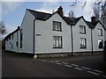
This large house on the edge of Ash Priors could well have been the Inn marked on old maps.
Image: © Barbara Cook
Taken: 18 Apr 2006
0.13 miles
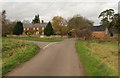
7
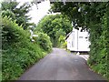
Lane at Ash Priors
The footpath sign indicates footpath T1/11 leaving on the right. The road junction further on is with the lane leading into the village centre.
Image: © Derek Harper
Taken: 19 Nov 2009
0.14 miles
9
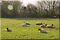
Ash Priors : Grassy Field & Sheep
Sheep grazing in a field in the village of Ash Priors.
Image: © Lewis Clarke
Taken: 21 Dec 2014
0.15 miles
10

Direction Sign - Signpost in Ash Priors village
Located on the west side of the T junction at Park Gate House at the west end of Ash Priors Road. Ash Priors parish. 3 arms and pyramid finial.
Milestone Society National ID: SO_ST1429
Image: © J Dowding
Taken: 20 May 2023
0.15 miles