IMAGES TAKEN NEAR TO
Combe Florey, TAUNTON, TA4 3JG
Introduction
This page details the photographs taken nearby to TA4 3JG by members of the Geograph project.
The Geograph project started in 2005 with the aim of publishing, organising and preserving representative images for every square kilometre of Great Britain, Ireland and the Isle of Man.

There are currently over 7.5m images from over14,400 individuals and you can help contribute to the project by visiting https://www.geograph.org.uk
Image Map (Loading...)


Getting Data...Please wait
Leaflet Map data © OpenStreetMap
Images are licensed for reuse under creativecommons.org/licenses/by-sa/2.0
Notes
- Clicking on the map will re-center to the selected point.
- The higher the marker number, the further away the image location is from the centre of the postcode.
Image Listing (5 Images Found)
Images are licensed for reuse under creativecommons.org/licenses/by-sa/2.0
Image
Details
Distance
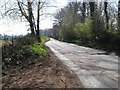
1
Combe Down Lane
Like many narrow lanes in the area, this road appears to have been abandoned by the county council, leaving numerous potholes and a build up of mud.
Image: © Roger Cornfoot
Taken: 2 Apr 2014
0.16 miles
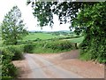
2
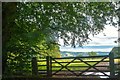
Combe Florey : Grassy Field & Gate
Looking into a field from the road.
Image: © Lewis Clarke
Taken: 1 Aug 2020
0.18 miles