IMAGES TAKEN NEAR TO
Combe Florey, TAUNTON, TA4 3JF
Introduction
This page details the photographs taken nearby to TA4 3JF by members of the Geograph project.
The Geograph project started in 2005 with the aim of publishing, organising and preserving representative images for every square kilometre of Great Britain, Ireland and the Isle of Man.

There are currently over 7.5m images from over14,400 individuals and you can help contribute to the project by visiting https://www.geograph.org.uk
Image Map
Images are licensed for reuse under creativecommons.org/licenses/by-sa/2.0
Notes
- Clicking on the map will re-center to the selected point.
- The higher the marker number, the further away the image location is from the centre of the postcode.
Image Listing (4 Images Found)
Images are licensed for reuse under creativecommons.org/licenses/by-sa/2.0
Image
Details
Distance
4
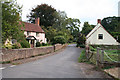
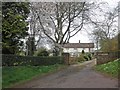
Combe Florey: village street
The street leads to Combe Florey church, the Old Manor House and on to a junction with the A358 Taunton-Minehead road. The village was home to the writer Evelyn Waugh, who died in 1966
Image: © Martin Bodman
Taken: 21 Sep 2005
0.25 miles