IMAGES TAKEN NEAR TO
Bagborough, TAUNTON, TA4 3EE
Introduction
This page details the photographs taken nearby to TA4 3EE by members of the Geograph project.
The Geograph project started in 2005 with the aim of publishing, organising and preserving representative images for every square kilometre of Great Britain, Ireland and the Isle of Man.

There are currently over 7.5m images from over14,400 individuals and you can help contribute to the project by visiting https://www.geograph.org.uk
Image Map
Images are licensed for reuse under creativecommons.org/licenses/by-sa/2.0
Notes
- Clicking on the map will re-center to the selected point.
- The higher the marker number, the further away the image location is from the centre of the postcode.
Image Listing (4 Images Found)
Images are licensed for reuse under creativecommons.org/licenses/by-sa/2.0
Image
Details
Distance
1
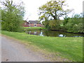
Channel to Channel (421)
This is a look across the pond at Breach Barton.
Image: © Shazz
Taken: 30 Apr 2015
0.05 miles
2
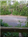
Channel to Channel (422)
The path crosses an unnamed lane into woodland.
Image: © Shazz
Taken: 30 Apr 2015
0.09 miles
3
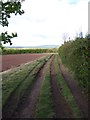
Channel to Channel (423)
The path continues by the field edge with Exmoor on the skyline.
Image: © Shazz
Taken: 30 Apr 2015
0.15 miles
4
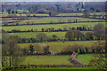
West Bagborough : Countryside Scenery
Looking out across the grassy fields and countryside.
Image: © Lewis Clarke
Taken: 7 Mar 2020
0.21 miles