IMAGES TAKEN NEAR TO
Cothelstone, TAUNTON, TA4 3DP
Introduction
This page details the photographs taken nearby to TA4 3DP by members of the Geograph project.
The Geograph project started in 2005 with the aim of publishing, organising and preserving representative images for every square kilometre of Great Britain, Ireland and the Isle of Man.

There are currently over 7.5m images from over14,400 individuals and you can help contribute to the project by visiting https://www.geograph.org.uk
Image Map
Images are licensed for reuse under creativecommons.org/licenses/by-sa/2.0
Notes
- Clicking on the map will re-center to the selected point.
- The higher the marker number, the further away the image location is from the centre of the postcode.
Image Listing (8 Images Found)
Images are licensed for reuse under creativecommons.org/licenses/by-sa/2.0
Image
Details
Distance
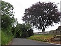
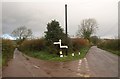
2
Junction on Cothelstone Road
A crossroads; the lane in the foreground is the lane shown in Image, some 750 metres further northwest.
Image: © Derek Harper
Taken: 27 Nov 2009
0.02 miles
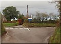
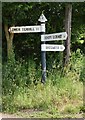
3
Somerset County Council finger post
A junction under the Quantock Hills with the usual pyramid topped fingerpost.
Image: © Richard Webb
Taken: 1 Apr 2012
0.02 miles
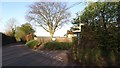
4
SCC Fingerpost at Bishops Lydeard, Cotelstone Road
Image: © Andrew Riley
Taken: 6 Jun 2018
0.02 miles
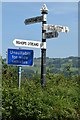
5

A narrow lane
A narrow and sunken lane. Not easy to pass a vehicle, even on a bike.
Image: © Richard Webb
Taken: 1 Apr 2012
0.05 miles
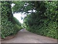
7
Junction on Cothelstone Road (2)
A fork about 400 metres away along Cothelstone Road (right) from Image
Image: © Derek Harper
Taken: 27 Nov 2009
0.25 miles
8
SCC Fingerpost North of Bishops Lydeard
Image: © Andrew Riley
Taken: 6 Jun 2018
0.25 miles