IMAGES TAKEN NEAR TO
Chipstable, TAUNTON, TA4 2PY
Introduction
This page details the photographs taken nearby to TA4 2PY by members of the Geograph project.
The Geograph project started in 2005 with the aim of publishing, organising and preserving representative images for every square kilometre of Great Britain, Ireland and the Isle of Man.

There are currently over 7.5m images from over14,400 individuals and you can help contribute to the project by visiting https://www.geograph.org.uk
Image Map
Images are licensed for reuse under creativecommons.org/licenses/by-sa/2.0
Notes
- Clicking on the map will re-center to the selected point.
- The higher the marker number, the further away the image location is from the centre of the postcode.
Image Listing (21 Images Found)
Images are licensed for reuse under creativecommons.org/licenses/by-sa/2.0
Image
Details
Distance

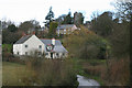
4
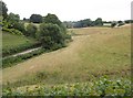
Valley below Chipstable
Taken from the lane southeast from the village, as it drops to meet the lane in the valley; together they descend the valley to Waterrow.
Image: © Derek Harper
Taken: 7 Jul 2010
0.09 miles

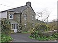
6
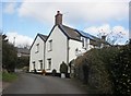
Elm Green, Chipstable
Corner house, seen from another angle, here: Image
Image: © Roger Cornfoot
Taken: 18 Feb 2015
0.14 miles
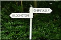
7
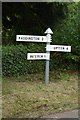
SCC Fingerpost at Chipstable
3 fingered SCC Post.
Image: © Andrew Riley
Taken: 4 Jun 2018
0.15 miles
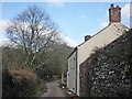
8
Chipstable: the village
Seen from Pitt Lane; looking north west
Image: © Martin Bodman
Taken: 1 Apr 2006
0.15 miles
9

Lychgate, All Saints Church, Chipstable
Image: © Roger Cornfoot
Taken: 29 Mar 2014
0.16 miles