IMAGES TAKEN NEAR TO
Luxton Way, TAUNTON, TA4 2BW
Introduction
This page details the photographs taken nearby to Luxton Way, TA4 2BW by members of the Geograph project.
The Geograph project started in 2005 with the aim of publishing, organising and preserving representative images for every square kilometre of Great Britain, Ireland and the Isle of Man.

There are currently over 7.5m images from over14,400 individuals and you can help contribute to the project by visiting https://www.geograph.org.uk
Image Map
Images are licensed for reuse under creativecommons.org/licenses/by-sa/2.0
Notes
- Clicking on the map will re-center to the selected point.
- The higher the marker number, the further away the image location is from the centre of the postcode.
Image Listing (45 Images Found)
Images are licensed for reuse under creativecommons.org/licenses/by-sa/2.0
Image
Details
Distance
1
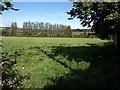
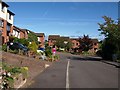
Meadow, Wiveliscombe
Taken from Style Road; the other side of the road is built-up. Behind the row of poplars is a rugby ground.
Image: © Derek Harper
Taken: 29 Sep 2009
0.02 miles
2
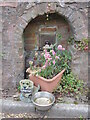
Water in Style Street
An old fountain is still respected at the bottom of the hill. See Image] for a location view.
Image: © Neil Owen
Taken: 18 Jun 2024
0.04 miles
3

Along Style Street
Apart from the old cottages and newer houses, there is an old water source set into the wall. See Image] for a closer look.
Image: © Neil Owen
Taken: 18 Jun 2024
0.04 miles
4
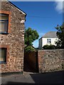
West Deane Way, Wiveliscombe
The Way leaves Style Road on the northern edge of the town through the gap beside this house.
Image: © Derek Harper
Taken: 29 Sep 2009
0.05 miles
5
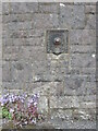
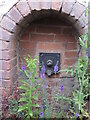
A Scottish water supply
The length of Golden Hill in Wiveliscombe is dotted with a number of public water fountains. This one is at the junction with Burges Close and shows the square plate, tap and spout that was made by the Kilmarnock foundry of Thomas Kennedy.
Thomas Kennedy (senior) was born in Argylshire but moved to Kilmarnock in 1824. Principally a watch and clockmaker he became involved in making a water meter system with his partner, John Cameron. The firm made several products for the water industry, and Wiveliscombe has several still surviving, although it seems none actually dispense water any more.
Image: © Neil Owen
Taken: 18 Jun 2024
0.08 miles

7
Coopers Heights, Wiveliscombe
A residential cul-de-sac at the end of Old Brewery Road, seen from the point where a footpath from Golden Hill emerges.
Image: © Derek Harper
Taken: 29 Sep 2009
0.12 miles
8
Golden Hill fountain
There are a few such old water fountains on Golden Hill. This one is similar to the others but has the mark of 'Glenfield', not Kennedy. Glenfield was a large iron foundry and associated industrial site in Kilmarnock that started life in the nineteenth century. Thomas Kennedy started producing water metering items and the firms merged later on.
Image: © Neil Owen
Taken: 18 Jun 2024
0.12 miles
9
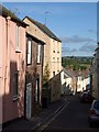
Golden Hill, Wiveliscombe
Taken from a little further down the hill than Image The street winds attractively down the hill away from the town centre.
Image: © Derek Harper
Taken: 29 Sep 2009
0.12 miles
10
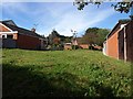
Spring Gardens, Wiveliscombe
A grassy plot between Spring Gardens and a footpath which links Style Road to the town centre.
Image: © Derek Harper
Taken: 29 Sep 2009
0.13 miles