IMAGES TAKEN NEAR TO
Waterrow, TAUNTON, TA4 2AU
Introduction
This page details the photographs taken nearby to TA4 2AU by members of the Geograph project.
The Geograph project started in 2005 with the aim of publishing, organising and preserving representative images for every square kilometre of Great Britain, Ireland and the Isle of Man.

There are currently over 7.5m images from over14,400 individuals and you can help contribute to the project by visiting https://www.geograph.org.uk
Image Map
Images are licensed for reuse under creativecommons.org/licenses/by-sa/2.0
Notes
- Clicking on the map will re-center to the selected point.
- The higher the marker number, the further away the image location is from the centre of the postcode.
Image Listing (4 Images Found)
Images are licensed for reuse under creativecommons.org/licenses/by-sa/2.0
Image
Details
Distance
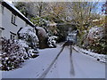
1

Waterrow : Country Lane
A country lane heading through the outskirts of Waterrow.
Image: © Lewis Clarke
Taken: 15 Sep 2019
0.15 miles
2
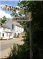
Direction Sign ? Signpost
Located on the south side of the T junction in Waterrow in Chipstable parish. 2 arms but no finial.
Milestone Society National ID: SO_ST0525
Image: © N Savage
Taken: 7 Jul 2019
0.15 miles
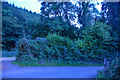
3
View towards Trowell Farm
... outside Waterrow
Image: © Ian T
Taken: 25 Nov 2005
0.15 miles
4
Waterrow : Country Lane
Looking along a country lane in Waterrow.
Image: © Lewis Clarke
Taken: 15 Sep 2019
0.17 miles