IMAGES TAKEN NEAR TO
St. Lukes Mews, TAUNTON, TA4 1NT
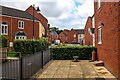
Introduction
This page details the photographs taken nearby to St. Lukes Mews, TA4 1NT by members of the Geograph project.
The Geograph project started in 2005 with the aim of publishing, organising and preserving representative images for every square kilometre of Great Britain, Ireland and the Isle of Man.

There are currently over 7.5m images from over14,400 individuals and you can help contribute to the project by visiting https://www.geograph.org.uk
Image Map (Loading...)


Getting Data...Please wait
Leaflet Map data © OpenStreetMap
Images are licensed for reuse under creativecommons.org/licenses/by-sa/2.0
Notes
- Clicking on the map will re-center to the selected point.
- The higher the marker number, the further away the image location is from the centre of the postcode.
Image Listing (38 Images Found)
Images are licensed for reuse under creativecommons.org/licenses/by-sa/2.0
Image
Details
Distance
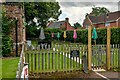
1
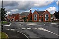
Cotford St Luke : Graham Way
A roundabout on Graham Way.
Image: © Lewis Clarke
Taken: 26 Aug 2023
0.03 miles
2
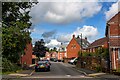
Cotford St Luke : Merifields
Looking along Merifields off Graham Way.
Image: © Lewis Clarke
Taken: 26 Aug 2023
0.04 miles
3
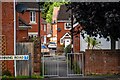
Cotford St Luke : Footpath
A footpath heads from Manning Road to Merrifields.
Image: © Lewis Clarke
Taken: 26 Aug 2023
0.04 miles
4
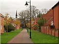
Path at Cotford St Luke
At the end on the left is the chapel of St Luke, which gives the development its name, and which is the main structure remaining from Tone Vale Hospital. "1897-98 by Giles, Gough & Trollope who also designed the hospital" http://www.imagesofengland.org.uk/Details/Default.aspx?id=361629&mode=adv , and distinguished by a flèche. Seen from Graham Way.
Image: © Derek Harper
Taken: 19 Nov 2009
0.05 miles
5
Cotford St Luke : Church of St Luke Chapel
The chapel was built to serve the 2nd County of Somerset and City of Bath Pauper Lunatic Asylum, now Tone Vale Hospital and is now a place to eat.
Image: © Lewis Clarke
Taken: 26 Aug 2023
0.05 miles
6
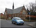
St Luke's Chapel, Cotford
Originally in the grounds of Cotford lunatic asylum. Now converted into a public house and restaurant.
Image: © Roger Cornfoot
Taken: 2 Apr 2014
0.06 miles
7
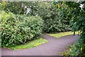
Cotford St Luke : Footpath
Looking along a path.
Image: © Lewis Clarke
Taken: 26 Aug 2023
0.06 miles
8

Cotford St Luke : Footpath
A footpath through Cotford St Luke.
Image: © Lewis Clarke
Taken: 26 Aug 2023
0.06 miles
9
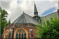
Cotford St Luke : Church of St Luke Chapel
The chapel was built to serve the 2nd County of Somerset and City of Bath Pauper Lunatic Asylum, now Tone Vale Hospital. It's now a place to eat.
Image: © Lewis Clarke
Taken: 26 Aug 2023
0.06 miles
10
Cotford St Luke : Burge Crescent
Looking along Burge Crescent.
Image: © Lewis Clarke
Taken: 26 Aug 2023
0.08 miles