IMAGES TAKEN NEAR TO
Courtfield, TAUNTON, TA4 1NB
Introduction
This page details the photographs taken nearby to Courtfield, TA4 1NB by members of the Geograph project.
The Geograph project started in 2005 with the aim of publishing, organising and preserving representative images for every square kilometre of Great Britain, Ireland and the Isle of Man.

There are currently over 7.5m images from over14,400 individuals and you can help contribute to the project by visiting https://www.geograph.org.uk
Image Map
Images are licensed for reuse under creativecommons.org/licenses/by-sa/2.0
Notes
- Clicking on the map will re-center to the selected point.
- The higher the marker number, the further away the image location is from the centre of the postcode.
Image Listing (9 Images Found)
Images are licensed for reuse under creativecommons.org/licenses/by-sa/2.0
Image
Details
Distance
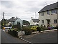
2
House on Butts Way, Milverton
There is a very noisy dog at Longview. Taken from the point where sestricted byway WG 7/48 leaves the lane.
Image: © Derek Harper
Taken: 1 Feb 2010
0.09 miles
3
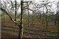
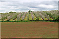
Milverton: orchard near Olands
A public footpath runs through the orchard to Milverton Court
Image: © Martin Bodman
Taken: 11 Feb 2006
0.12 miles
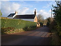
4
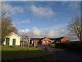
Milverton Cricket Club
Occupying a smart building on Butts Way, with its ground on the north side.
Image: © Derek Harper
Taken: 1 Feb 2010
0.16 miles
5
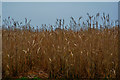
Taunton Deane : Crop Field
A field of crops seen from the road.
Image: © Lewis Clarke
Taken: 24 Dec 2018
0.17 miles
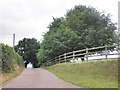
7
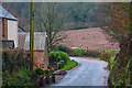
Taunton Deane : Burn Hill B3187
A road approaching Smallbrook.
Image: © Lewis Clarke
Taken: 24 Dec 2018
0.20 miles
8
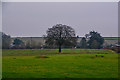
Milverton : Grassy Field
A grassy field in the countryside at Milverton.
Image: © Lewis Clarke
Taken: 24 Dec 2018
0.20 miles