IMAGES TAKEN NEAR TO
Ashmeads Close, TA4 1FL
Introduction
This page details the photographs taken nearby to Ashmeads Close, TA4 1FL by members of the Geograph project.
The Geograph project started in 2005 with the aim of publishing, organising and preserving representative images for every square kilometre of Great Britain, Ireland and the Isle of Man.

There are currently over 7.5m images from over14,400 individuals and you can help contribute to the project by visiting https://www.geograph.org.uk
Image Map (Loading...)


Getting Data...Please wait
Leaflet Map data © OpenStreetMap
Images are licensed for reuse under creativecommons.org/licenses/by-sa/2.0
Notes
- Clicking on the map will re-center to the selected point.
- The higher the marker number, the further away the image location is from the centre of the postcode.
Image Listing (9 Images Found)
Images are licensed for reuse under creativecommons.org/licenses/by-sa/2.0
Image
Details
Distance
3
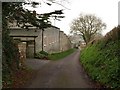
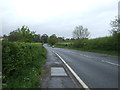
Lane past Elms Farm
The descent from Stonegallows Hill towards Ritherden's Farm is echoed by the distinctive stepped wall coping by the farm.
Image: © Derek Harper
Taken: 11 Mar 2009
0.15 miles
4
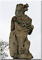
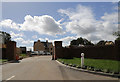
Griffin on pillar - Rumwell
Two pillars at the entrance to a house.
Image: © Nick Chipchase
Taken: 30 Mar 2009
0.15 miles
6
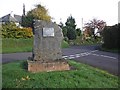
Monument at Stonegallows
Site of Taunton's former place of execution. Not a place to hang about....
Image: © Roger Cornfoot
Taken: 13 Nov 2013
0.18 miles
7
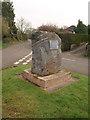
Stonegallows
The stone commemorates the fact that this was Taunton's execution site from 1575 to 1810. It is now a surprisingly salubrious residential area.
Image: © Derek Harper
Taken: 11 Mar 2009
0.18 miles
8
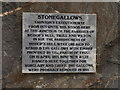
Stonegallows
A close-up of the plaque on the commemorative stone shown in Image
Image: © Derek Harper
Taken: 11 Mar 2009
0.18 miles