IMAGES TAKEN NEAR TO
Blagdon Hill, TAUNTON, TA3 7SL
Introduction
This page details the photographs taken nearby to TA3 7SL by members of the Geograph project.
The Geograph project started in 2005 with the aim of publishing, organising and preserving representative images for every square kilometre of Great Britain, Ireland and the Isle of Man.

There are currently over 7.5m images from over14,400 individuals and you can help contribute to the project by visiting https://www.geograph.org.uk
Image Map
Images are licensed for reuse under creativecommons.org/licenses/by-sa/2.0
Notes
- Clicking on the map will re-center to the selected point.
- The higher the marker number, the further away the image location is from the centre of the postcode.
Image Listing (25 Images Found)
Images are licensed for reuse under creativecommons.org/licenses/by-sa/2.0
Image
Details
Distance
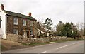
1
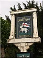
Pub sign, Blagdon Hill
The sign for Image is across the road from the pub. The Lamb and Flag (that of St George) is the symbol of the Knights Templar.
Image: © Derek Harper
Taken: 6 Mar 2009
0.02 miles
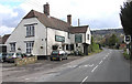
2
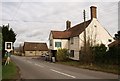
The Lamb and Flag, Blagdon Hill
This view of Image from the uphill side also includes Image The pub, described at http://www.imagesofengland.org.uk/Details/Default.aspx?id=271046&mode=adv , is "C17, possibly rebuild of earlier dwelling, altered early C19 and C20 ... full height gabled porch carried on timber posts ... This has been an inn since the C18 and probably earlier". The "road was turnpiked in 1752" http://webapp1.somerset.gov.uk/her/details.asp?prn=26227 and is clearly an important route from the Blackdown Hills down into Taunton.
Image: © Derek Harper
Taken: 6 Mar 2009
0.02 miles
4
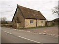
Blagdon Mission Room
"The Mission Room on the corner of the Green was erected for the benefit of parishioners living right up the hill. It is now a furniture store". From http://tinyurl.com/aaq66o
The building, at the junction with Curdleigh Lane, bears the date 1878.
Image: © Derek Harper
Taken: 6 Mar 2009
0.04 miles
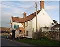
5
Farmhouse, Blagdon Hill
Originally a farmhouse, this is listed as "Wardour Cottage", and described as "late C16-early C17", with a Tuscan Doric porch of Ham stone. http://www.imagesofengland.org.uk/Details/Default.aspx?id=271050&mode=adv
Image: © Derek Harper
Taken: 6 Mar 2009
0.06 miles
6

Blagdon Hill : Grassy Field
A field at Blagddon Hill.
Image: © Lewis Clarke
Taken: 23 Mar 2022
0.07 miles
8

Blagdon Hill : Grassy Field
A grassy field with right of way through it.
Image: © Lewis Clarke
Taken: 23 Mar 2022
0.08 miles
9
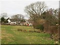
Blagdon Green
"Blagdon Green, a triangular field at the top of the village, was anciently the site of the pound, where straying cattle were penned, and the parish saw-pit operated there in the 18th century. The Green was enclosed and sold in 1851, but was still to be regarded as 'a place of Exercise and Recreation for the Inhabitants'" http://tinyurl.com/bnytxz
The 1.8 acre Blagdon Green was recently bought for the community, mainly through donations from nearby residents, who have helped lay the hedge alongside the road. Taken from footpath T21/74 which runs along the hypotenuse of the triangle.
Image: © Derek Harper
Taken: 6 Mar 2009
0.09 miles
10
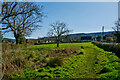
Blagdon Hill : Grassy Field
A grassy field with a right of way heading through.
Image: © Lewis Clarke
Taken: 23 Mar 2022
0.10 miles