IMAGES TAKEN NEAR TO
Trull, TAUNTON, TA3 7LE
Introduction
This page details the photographs taken nearby to TA3 7LE by members of the Geograph project.
The Geograph project started in 2005 with the aim of publishing, organising and preserving representative images for every square kilometre of Great Britain, Ireland and the Isle of Man.

There are currently over 7.5m images from over14,400 individuals and you can help contribute to the project by visiting https://www.geograph.org.uk
Image Map
Images are licensed for reuse under creativecommons.org/licenses/by-sa/2.0
Notes
- Clicking on the map will re-center to the selected point.
- The higher the marker number, the further away the image location is from the centre of the postcode.
Image Listing (118 Images Found)
Images are licensed for reuse under creativecommons.org/licenses/by-sa/2.0
Image
Details
Distance

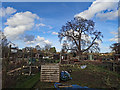
7
Old oak tree in Trull Meadow
Trull church in the background.
Image: © Nick Chipchase
Taken: 4 Nov 2013
0.08 miles
9
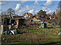
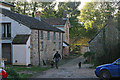
Trull allotments and The Old Rectory
Image: © Nick Chipchase
Taken: 16 Feb 2018
0.12 miles
10

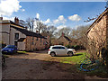
Trull : Brookside Close
Looking towards Brookside Close in Trull.
Image: © Lewis Clarke
Taken: 23 Aug 2015
0.13 miles