IMAGES TAKEN NEAR TO
Honiton Road, TAUNTON, TA3 7JW
Introduction
This page details the photographs taken nearby to Honiton Road, TA3 7JW by members of the Geograph project.
The Geograph project started in 2005 with the aim of publishing, organising and preserving representative images for every square kilometre of Great Britain, Ireland and the Isle of Man.

There are currently over 7.5m images from over14,400 individuals and you can help contribute to the project by visiting https://www.geograph.org.uk
Image Map
Images are licensed for reuse under creativecommons.org/licenses/by-sa/2.0
Notes
- Clicking on the map will re-center to the selected point.
- The higher the marker number, the further away the image location is from the centre of the postcode.
Image Listing (46 Images Found)
Images are licensed for reuse under creativecommons.org/licenses/by-sa/2.0
Image
Details
Distance
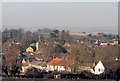
1

Channel to Channel (327)
This was taken from the field corner looking west over Trull.
Image: © Shazz
Taken: 26 Apr 2015
0.06 miles
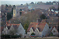


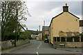
7
Trull Village
Looking south along Honiton Road at the junction with Dipford Road.
Image: © Alan Burke
Taken: 1 Jun 2008
0.11 miles
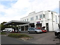
8
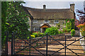
Trull : Trull Green Farm
Farmhouse. C16 enlarged C17, extended at rear early C19.
Image: © Lewis Clarke
Taken: 23 Aug 2015
0.12 miles
9
Dipford Road
Trull Green Farm in the distance.
Image: © Nick Chipchase
Taken: 6 Apr 2009
0.12 miles
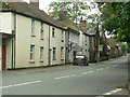
10
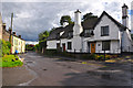
Trull : Dipford Road
Looking along Dipford Road with Gatchell Cottage in view.
Image: © Lewis Clarke
Taken: 23 Aug 2015
0.12 miles