IMAGES TAKEN NEAR TO
Furlong Green, TAUNTON, TA3 7JP
Introduction
This page details the photographs taken nearby to Furlong Green, TA3 7JP by members of the Geograph project.
The Geograph project started in 2005 with the aim of publishing, organising and preserving representative images for every square kilometre of Great Britain, Ireland and the Isle of Man.

There are currently over 7.5m images from over14,400 individuals and you can help contribute to the project by visiting https://www.geograph.org.uk
Image Map
Images are licensed for reuse under creativecommons.org/licenses/by-sa/2.0
Notes
- Clicking on the map will re-center to the selected point.
- The higher the marker number, the further away the image location is from the centre of the postcode.
Image Listing (117 Images Found)
Images are licensed for reuse under creativecommons.org/licenses/by-sa/2.0
Image
Details
Distance
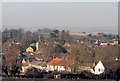
3

Channel to Channel (327)
This was taken from the field corner looking west over Trull.
Image: © Shazz
Taken: 26 Apr 2015
0.07 miles


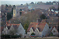
8
Trull Village
Looking south along Honiton Road at the junction with Dipford Road.
Image: © Alan Burke
Taken: 1 Jun 2008
0.11 miles

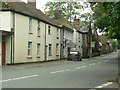
10
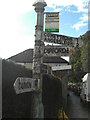
Direction Sign ? Signpost on Honiton Road in Trull
Located on the east side of the junction of Honiton Road and Dipford Road in Trull parish. 4 arms and pyramid finial.
Milestone Society National ID: SO_ST2122
Image: © T Jenkinson
Taken: 12 Oct 2012
0.13 miles