IMAGES TAKEN NEAR TO
Corfe, TAUNTON, TA3 7BZ
Introduction
This page details the photographs taken nearby to TA3 7BZ by members of the Geograph project.
The Geograph project started in 2005 with the aim of publishing, organising and preserving representative images for every square kilometre of Great Britain, Ireland and the Isle of Man.

There are currently over 7.5m images from over14,400 individuals and you can help contribute to the project by visiting https://www.geograph.org.uk
Image Map
Images are licensed for reuse under creativecommons.org/licenses/by-sa/2.0
Notes
- Clicking on the map will re-center to the selected point.
- The higher the marker number, the further away the image location is from the centre of the postcode.
Image Listing (5 Images Found)
Images are licensed for reuse under creativecommons.org/licenses/by-sa/2.0
Image
Details
Distance
1
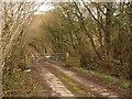
Track from Whitford Hill
This private track leads from the B3170 to the road from which Image was taken.
Image: © Derek Harper
Taken: 6 Mar 2009
0.12 miles
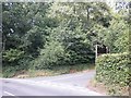
2
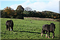
Corfe: on Whitford Hill
Looking west-south-west
Image: © Martin Bodman
Taken: 18 Nov 2006
0.15 miles
3
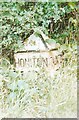
Old Milepost beside the B3170 on Whitford Hill
Cast iron post by the B3170, in parish of Corfe (Taunton Deane District), on the narrow roadside verge on the east side of Whitford Hill south of Corfe village. Taunton Allen iron casting, erected by the Local Highways Board in the 19th century.
Inscription reads:-
: HONITON / 13⅜ : : TAUNTON / 5 :
Maker:-
: ALLEN & Co / TAUNTON :
Grade II listed. List Entry Number: 1176853
https://historicengland.org.uk/listing/the-list/list-entry/1176853
Milestone Society National ID: SO_TAHO05
Image: © J Dowding
Taken: 26 Aug 2007
0.20 miles
4
Road to golf club
The private road to Image leaves a no through lane to Staple Lawns Farm.
Image: © Derek Harper
Taken: 6 Mar 2009
0.21 miles
5
Turning for Taunton and Pickeridge Golf Club
Image: © Roger Cornfoot
Taken: 2 Aug 2013
0.25 miles