IMAGES TAKEN NEAR TO
Duddlestone, TAUNTON, TA3 7BW
Introduction
This page details the photographs taken nearby to TA3 7BW by members of the Geograph project.
The Geograph project started in 2005 with the aim of publishing, organising and preserving representative images for every square kilometre of Great Britain, Ireland and the Isle of Man.

There are currently over 7.5m images from over14,400 individuals and you can help contribute to the project by visiting https://www.geograph.org.uk
Image Map
Images are licensed for reuse under creativecommons.org/licenses/by-sa/2.0
Notes
- Clicking on the map will re-center to the selected point.
- The higher the marker number, the further away the image location is from the centre of the postcode.
Image Listing (4 Images Found)
Images are licensed for reuse under creativecommons.org/licenses/by-sa/2.0
Image
Details
Distance
1
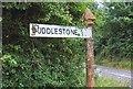
Old Direction Sign - Signpost on the B3170 at Duddlestone
Pyramid finial - 1 arm; Somerset SCC pyramid by the B3170, in parish of Pitminster (Taunton Deane District), on the northwest side of the T-junction of the B3170 and Fosgrove Lane, Duddlestone.
Surveyed
Milestone Society National ID: SO_ST2321
Image: © Milestone Society
Taken: Unknown
0.04 miles
2
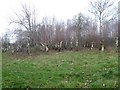
Pollarding near Duddlestone
A stand of silver birch trees which are evidently being harvested by pollarding; this is on the edge of Taunton racecourse - are the branches used on the course?
Image: © David Smith
Taken: 1 Jan 2019
0.05 miles
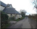
4

Bare trees by footpath north of Duddlestone
There is a footpath across the field from Duddlestone, passing these trees
Image: © David Smith
Taken: 1 Jan 2019
0.24 miles