IMAGES TAKEN NEAR TO
Stowey Road, TAUNTON, TA3 6PR
Introduction
This page details the photographs taken nearby to Stowey Road, TA3 6PR by members of the Geograph project.
The Geograph project started in 2005 with the aim of publishing, organising and preserving representative images for every square kilometre of Great Britain, Ireland and the Isle of Man.

There are currently over 7.5m images from over14,400 individuals and you can help contribute to the project by visiting https://www.geograph.org.uk
Image Map
Images are licensed for reuse under creativecommons.org/licenses/by-sa/2.0
Notes
- Clicking on the map will re-center to the selected point.
- The higher the marker number, the further away the image location is from the centre of the postcode.
Image Listing (5 Images Found)
Images are licensed for reuse under creativecommons.org/licenses/by-sa/2.0
Image
Details
Distance
1
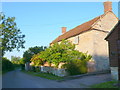
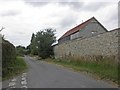
House at Stowey Farm
This house is on the minor road between Fivehead and Curry Mallet just to the south west of Fivehead.
Image: © Nigel Mykura
Taken: 22 Jul 2012
0.01 miles
2
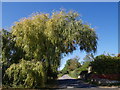
Willow over the lane at Stowey Farm
The lane from Fivehead past Stowey Farm, heading towards Curry Mallet. Footpath L11/1 leaves the lane on this side of the tree, heading SSW across fields to Iberry Lane. On the right is the garden of Pantiles.
Image: © Derek Harper
Taken: 15 Sep 2007
0.04 miles
5
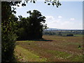
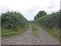
View along footpath L11/1
The footpath heads across this large field into ST3421, following vanished field boundaries. On the left, where the clump of trees jut out, is an old limekiln.
Image: © Derek Harper
Taken: 15 Sep 2007
0.16 miles