IMAGES TAKEN NEAR TO
Stoke St. Gregory, TAUNTON, TA3 6JG
Introduction
This page details the photographs taken nearby to TA3 6JG by members of the Geograph project.
The Geograph project started in 2005 with the aim of publishing, organising and preserving representative images for every square kilometre of Great Britain, Ireland and the Isle of Man.

There are currently over 7.5m images from over14,400 individuals and you can help contribute to the project by visiting https://www.geograph.org.uk
Image Map
Images are licensed for reuse under creativecommons.org/licenses/by-sa/2.0
Notes
- Clicking on the map will re-center to the selected point.
- The higher the marker number, the further away the image location is from the centre of the postcode.
Image Listing (12 Images Found)
Images are licensed for reuse under creativecommons.org/licenses/by-sa/2.0
Image
Details
Distance
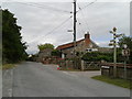
1
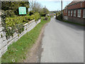
Looking east-northeast along Slough Lane
On the left is the information board of Image
Image: © John Baker
Taken: 6 Apr 2016
0.01 miles
2
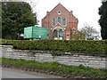
Stoke St Gregory Baptist Church, Slough Lane
Image: © John Baker
Taken: 6 Apr 2016
0.03 miles
4
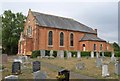
Stoke St Gregory Baptist church
Foundation stones show that this church, overlooking Slough Lane, was built in 1895 http://webapp1.somerset.gov.uk/her/details.asp?prn=41220 .
Image: © Derek Harper
Taken: 9 Aug 2010
0.03 miles
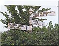
7
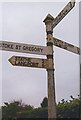
Old Direction Sign - Signpost by Meare Green, Stoke St Gregory Parish
Pyramid finial - 4 arms; Somerset SCC pyramid by the UC road, in parish of Stoke St Gregory (Taunton Deane District), junction of lanes between Windmill Hill and Lane End Farm.
Surveyed
Milestone Society National ID: SO_ST3427A
Image: © Milestone Society
Taken: Unknown
0.09 miles
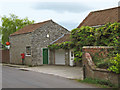
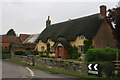
8
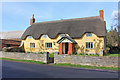
Griggs Hill
Thatched cottage on Griggs Hill.
Image: © Wayland Smith
Taken: 22 Feb 2014
0.10 miles
9
Old Direction Sign - Signpost by Slough Lane, north of Stoke St Gregory
Pyramid finial - 3 arms; Somerset SCC pyramid by the UC road, in parish of Stoke St Gregory (Taunton Deane District), Willey Road junction with Slough Lane.
Surveyed
Milestone Society National ID: SO_ST3427B.
Image: © Milestone Society
Taken: Unknown
0.11 miles
10
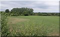
Field, Stoke St Gregory
The field to the rear of Image, with the land sloping towards the Somerset Levels.
Image: © Derek Harper
Taken: 9 Aug 2010
0.14 miles