IMAGES TAKEN NEAR TO
Huntham, TAUNTON, TA3 6HU
Introduction
This page details the photographs taken nearby to Huntham, TA3 6HU by members of the Geograph project.
The Geograph project started in 2005 with the aim of publishing, organising and preserving representative images for every square kilometre of Great Britain, Ireland and the Isle of Man.

There are currently over 7.5m images from over14,400 individuals and you can help contribute to the project by visiting https://www.geograph.org.uk
Image Map
Images are licensed for reuse under creativecommons.org/licenses/by-sa/2.0
Notes
- Clicking on the map will re-center to the selected point.
- The higher the marker number, the further away the image location is from the centre of the postcode.
Image Listing (6 Images Found)
Images are licensed for reuse under creativecommons.org/licenses/by-sa/2.0
Image
Details
Distance
1
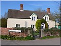
Corner Cottage Meare Green
Meare Green is on a small raised ridge between the Somerset levels of Curry Level to the north and West Sedgemoor to the south. Corner Cottage is on the corner of Huntham Lane leading south from Meare to the hamlet of Huntham on the edge of West Sedgemoor.
Image: © Nigel Mykura
Taken: 15 Apr 2010
0.13 miles
3

Old Direction Sign - Signpost by Meare Green, Stoke St Gregory Parish
Pyramid finial - 1 arm; Somerset SCC pyramid by the UC road, in parish of Stoke St Gregory (Taunton Deane District), Meare Green.
Surveyed
Milestone Society National ID: SO_ST3326
Image: © Milestone Society
Taken: Unknown
0.15 miles
5
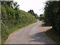
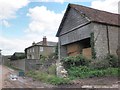
Huntham Road
The continuation of Huntham Lane, seen from near the junction with the lane to Meare Green.
Image: © Derek Harper
Taken: 9 Jun 2007
0.22 miles