IMAGES TAKEN NEAR TO
Oldway Lane, TAUNTON, TA3 6DE
Introduction
This page details the photographs taken nearby to Oldway Lane, TA3 6DE by members of the Geograph project.
The Geograph project started in 2005 with the aim of publishing, organising and preserving representative images for every square kilometre of Great Britain, Ireland and the Isle of Man.

There are currently over 7.5m images from over14,400 individuals and you can help contribute to the project by visiting https://www.geograph.org.uk
Image Map
Images are licensed for reuse under creativecommons.org/licenses/by-sa/2.0
Notes
- Clicking on the map will re-center to the selected point.
- The higher the marker number, the further away the image location is from the centre of the postcode.
Image Listing (10 Images Found)
Images are licensed for reuse under creativecommons.org/licenses/by-sa/2.0
Image
Details
Distance
1
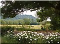
Field at Wrantage
A glimpse beneath a large ash tree from the A378. In the background is Line Wood on the Lias scarp.
Image: © Derek Harper
Taken: 3 Jul 2006
0.14 miles
2
Wheatfield, Wrantage
This field is pretty much in the centre of Wrantage, which is scattered along the A358. Picture taken from junction of A358 with Oldway Lane.
Image: © Derek Harper
Taken: 3 Jul 2006
0.15 miles
3
Old Post Office, Wrantage
Shown on the maps as a post office, but now a private house in this village which is strung out along the A378.
Image: © Derek Harper
Taken: 3 Jul 2006
0.19 miles
4
Former Methodist chapel, Wrantage
Now a house
Image: © David Smith
Taken: 21 Apr 2017
0.19 miles
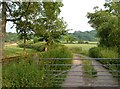
5
Bridge across ditch, Wrantage
Image: © Derek Harper
Taken: 3 Jul 2006
0.19 miles
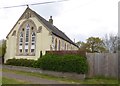
6
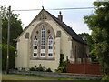
Former Methodist Chapel, Wrantage
On the A378. Now a private dwelling.
Image: © Derek Harper
Taken: 3 Jul 2006
0.20 miles
7
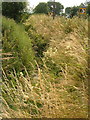
Ditch beside A378, Wrantage
Meadowsweet prominent among the wildflowers and grasses in this roadside drainage ditch. House visible top right is Image
Image: © Derek Harper
Taken: 3 Jul 2006
0.20 miles
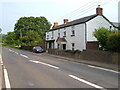
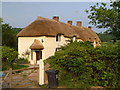
8
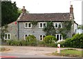
Cottage at Wrantage
A cottage completely built of blue lias, seen across the A378 at the junction with Oldway Lane.
Image: © Derek Harper
Taken: 3 Jul 2006
0.22 miles
9
Oldsway Cottage, Wrantage
More detail at http://www.imagesofengland.org.uk/search/details.aspx?pid=1&id=270873 - the windows have been repainted since that photo was taken. The former farmhouse is at right angles to the main road.
Image: © Derek Harper
Taken: 3 Jul 2006
0.22 miles
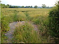
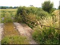
10
Track, Wrantage
Leading away from the A378 past the rear of Higher Wrantage Farm and carrying a footpath that heads straight for the lias scarp at Crimson Hill (background) and climbs it. I would give you the footpath number, but the Somerset website map that tells me is down again.
Image: © Derek Harper
Taken: 3 Jul 2006
0.25 miles