IMAGES TAKEN NEAR TO
Stoneyhead, TAUNTON, TA3 6BZ
Introduction
This page details the photographs taken nearby to Stoneyhead, TA3 6BZ by members of the Geograph project.
The Geograph project started in 2005 with the aim of publishing, organising and preserving representative images for every square kilometre of Great Britain, Ireland and the Isle of Man.

There are currently over 7.5m images from over14,400 individuals and you can help contribute to the project by visiting https://www.geograph.org.uk
Image Map
Images are licensed for reuse under creativecommons.org/licenses/by-sa/2.0
Notes
- Clicking on the map will re-center to the selected point.
- The higher the marker number, the further away the image location is from the centre of the postcode.
Image Listing (7 Images Found)
Images are licensed for reuse under creativecommons.org/licenses/by-sa/2.0
Image
Details
Distance
1
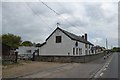
The Old Wheelwright's, Stony Head
This was formerly a Beer House (abbreviated to BH on OS maps) called the Wheelwright's Arms
Image: © David Smith
Taken: 21 Apr 2017
0.07 miles
4
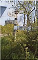
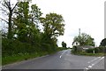
Old Direction Sign - Signpost by the A378, Stonehead Hill, Thornfalcon Parish
Pyramid finial - 3 arms; Somerset SCC pyramid by the A378, in parish of Thornfalcon (Taunton Deane District), Stonehead Hill, junction with Solomon's Hollow.
Surveyed
Milestone Society National ID: SO_ST2822
Image: © Milestone Society
Taken: Unknown
0.25 miles
5
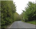
Junction at Mattock's Tree Green
The road on the left is Solomon's Hollow
Image: © David Smith
Taken: 21 Apr 2017
0.25 miles
6
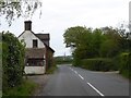
Rose Cottage at the junction of Solomon's Hollow and A378
Image: © David Smith
Taken: 21 Apr 2017
0.25 miles
7
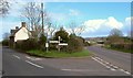
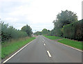
Junction at Mattock's Tree Green
300 metres east of Image], a side road branches off from the A378 (right) along a sandstone ridge to North Curry.
Image: © Derek Harper
Taken: 1 Apr 2006
0.25 miles