IMAGES TAKEN NEAR TO
Knapp, TAUNTON, TA3 6BQ
Introduction
This page details the photographs taken nearby to Knapp, TA3 6BQ by members of the Geograph project.
The Geograph project started in 2005 with the aim of publishing, organising and preserving representative images for every square kilometre of Great Britain, Ireland and the Isle of Man.

There are currently over 7.5m images from over14,400 individuals and you can help contribute to the project by visiting https://www.geograph.org.uk
Image Map
Images are licensed for reuse under creativecommons.org/licenses/by-sa/2.0
Notes
- Clicking on the map will re-center to the selected point.
- The higher the marker number, the further away the image location is from the centre of the postcode.
Image Listing (10 Images Found)
Images are licensed for reuse under creativecommons.org/licenses/by-sa/2.0
Image
Details
Distance
1
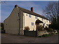
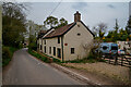
The Rising Sun has set
The pub in Lower Knapp closed in 2001 and has now been converted into a house. The building was a "16th century cross-passage farmhouse", according to www.tauntondeane.gov.uk/Forms/3-Creech.pdf .
Edit, March 2011: Thanks to Duncan for telling me that the pub reopened in 2010.
Image: © Derek Harper
Taken: 24 Mar 2007
0.12 miles
2
The Rising Sun, Lower Knapp
This charming country pub is seen here in October 1999, but closed down seemingly for good in the following decade. See Image It did, however, reopen but, at the time of writing in June 2020, is 'closed temporarily due to the end of a tenancy' - it would in any case be closed due to the Covid-19 pandemic.
Image: © Stephen McKay
Taken: Unknown
0.12 miles
3
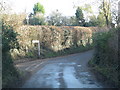
Collapsing barn, Lower Knapp
The lane to Haymoor End passes a derelict barn as it drops towards the Tone valley.
Image: © Derek Harper
Taken: 24 Mar 2007
0.15 miles
4
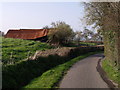
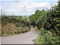
Combe Lane, Knapp
A minor road (cul-de-sac) which leads from Knapp to Lower Knapp
Image: © David Smith
Taken: 26 Dec 2015
0.15 miles
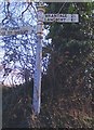
6
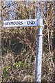
Old Direction Sign - Signpost by Knapp Road, Lower Knapp
Lost finial - 1 arm; Somerset SCC pyramid by the UC road, in parish of North Curry (Taunton Deane District), Knapp Road junction with lane to Lower Knapp, Southeast of Lower Knapp.
Surveyed
Milestone Society National ID: SO_ST3025A
Image: © Milestone Society
Taken: Unknown
0.19 miles
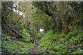
7
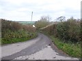
North Curry : Country Lane
Looking along a small lane.
Image: © Lewis Clarke
Taken: 1 Apr 2021
0.21 miles
8
North Curry : Footpath
A footpath heading up the hill.
Image: © Lewis Clarke
Taken: 1 Apr 2021
0.24 miles
9
Old Direction Sign - Signpost by Knapp Road, Lower Knapp
Pyramid finial - 2 arms; Somerset SCC pyramid by the UC road, in parish of North Curry (Taunton Deane District), Knapp Lane junction with Knapp Road, Southeast of Lower Knapp.
Surveyed
Milestone Society National ID: SO_ST3025B
Image: © Milestone Society
Taken: Unknown
0.25 miles