IMAGES TAKEN NEAR TO
Knapp, TAUNTON, TA3 6BB
Introduction
This page details the photographs taken nearby to Knapp, TA3 6BB by members of the Geograph project.
The Geograph project started in 2005 with the aim of publishing, organising and preserving representative images for every square kilometre of Great Britain, Ireland and the Isle of Man.

There are currently over 7.5m images from over14,400 individuals and you can help contribute to the project by visiting https://www.geograph.org.uk
Image Map
Images are licensed for reuse under creativecommons.org/licenses/by-sa/2.0
Notes
- Clicking on the map will re-center to the selected point.
- The higher the marker number, the further away the image location is from the centre of the postcode.
Image Listing (17 Images Found)
Images are licensed for reuse under creativecommons.org/licenses/by-sa/2.0
Image
Details
Distance
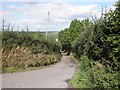
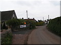
2
Side road in Knapp
Leading to several farms and fields beside the River Tone
Image: © David Smith
Taken: 26 Dec 2015
0.01 miles
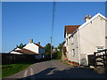
3
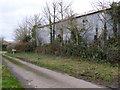
Large barn in Knapp
The side road leads to several farms and fields between the village and the River Tone
Image: © David Smith
Taken: 26 Dec 2015
0.02 miles
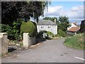
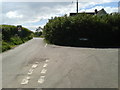
5
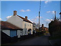
Houses in Knapp
Knapp is a small village on top of a prominent hill to the east of Creech St Michael above the West Moor Levels. The road on the left drops down towards Bird's farm.
Image: © Nigel Mykura
Taken: 22 Jul 2012
0.04 miles
6
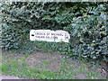
Road Sign
This old cast metal road sign shows the direction for Creech St Michael and Thornfalcon. It is buried in a hedge in Knapp.
Image: © Nigel Mykura
Taken: 22 Jul 2012
0.04 miles
8
The Triangle, Knapp
The Triangle, the house on the left, occupies a triangular site bounded by lanes in the scattered hamlet of Knapp, on a hill overlooking the Tone Valley. The brick building beyond is a withy boiler, apparently still in use (certainly in 1998, according to http://webapp1.somerset.gov.uk/her/details.asp?prn=43340 .) An explanation is at http://www.somerset.gov.uk/somerset/cultureheritage/heritage/info/monumentandartefacttypes/MonumentArtefactTypesW.cfm - as that link no longer works, here is its text, from http://web.archive.org/web/20040105170034/http://www.somerset.gov.uk/somerset/cultureheritage/heritage/info/monumentandartefacttypes/MonumentArtefactTypesW.cfm : "A device used for boiling sections of willow in order to increase its pliability, so that it can be woven to make such items as baskets. Withy boilers are common in wetland areas, such as Somerset, where willows grow and the industry flourished. Willow rods (withies) were cut in the winter and boiled for a day before they could be used. Often the boilers were built of brick with a chimney, the boiler being a metal container.
A brick built example survives at Knapp in North Curry and was still in use as recently as 1998"
Image: © Derek Harper
Taken: 11 Feb 2006
0.07 miles
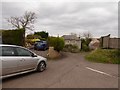
9
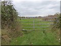
A little-used gate, Knapp
This field gate on the edge of the village appears to be little-used; the lush grass has grown to the lowest bar of the gate
Image: © David Smith
Taken: 26 Dec 2015
0.10 miles