IMAGES TAKEN NEAR TO
Knapp Lane, TAUNTON, TA3 6AU
Introduction
This page details the photographs taken nearby to Knapp Lane, TA3 6AU by members of the Geograph project.
The Geograph project started in 2005 with the aim of publishing, organising and preserving representative images for every square kilometre of Great Britain, Ireland and the Isle of Man.

There are currently over 7.5m images from over14,400 individuals and you can help contribute to the project by visiting https://www.geograph.org.uk
Image Map
Images are licensed for reuse under creativecommons.org/licenses/by-sa/2.0
Notes
- Clicking on the map will re-center to the selected point.
- The higher the marker number, the further away the image location is from the centre of the postcode.
Image Listing (40 Images Found)
Images are licensed for reuse under creativecommons.org/licenses/by-sa/2.0
Image
Details
Distance
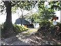
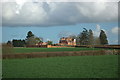
3
North Curry : Track
A track to Knapp Lane Farmhouse.
Image: © Lewis Clarke
Taken: 1 Apr 2021
0.05 miles
4
North Curry : Lockyers Field
Looking along Lockyers Field.
Image: © Lewis Clarke
Taken: 1 Apr 2021
0.07 miles
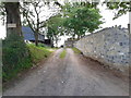
6
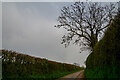
North Curry : Knapp Lane
Looking along Knapp Lane.
Image: © Lewis Clarke
Taken: 1 Apr 2021
0.12 miles
7
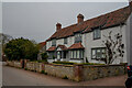
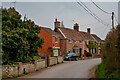
North Curry : Walnut Tree Cottage
On Knapp Lane.
Image: © Lewis Clarke
Taken: 1 Apr 2021
0.12 miles
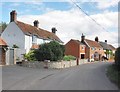
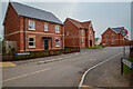
9
North Curry : Knapp Lane
Looking along Knapp Lane.
Image: © Lewis Clarke
Taken: 1 Apr 2021
0.14 miles
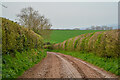
10
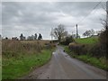
Knapp Lane crossing Badlinch Hollow
There is a very small stream in this valley
Image: © David Smith
Taken: 26 Dec 2015
0.15 miles