IMAGES TAKEN NEAR TO
Curland, TAUNTON, TA3 5SA
Introduction
This page details the photographs taken nearby to TA3 5SA by members of the Geograph project.
The Geograph project started in 2005 with the aim of publishing, organising and preserving representative images for every square kilometre of Great Britain, Ireland and the Isle of Man.

There are currently over 7.5m images from over14,400 individuals and you can help contribute to the project by visiting https://www.geograph.org.uk
Image Map
Images are licensed for reuse under creativecommons.org/licenses/by-sa/2.0
Notes
- Clicking on the map will re-center to the selected point.
- The higher the marker number, the further away the image location is from the centre of the postcode.
Image Listing (6 Images Found)
Images are licensed for reuse under creativecommons.org/licenses/by-sa/2.0
Image
Details
Distance
1
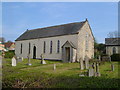
Curland Methodist Chapel
The former Wesleyan chapel dates from 1824 with later alterations http://webapp1.somerset.gov.uk/her/details.asp?prn=18064 . It ceased use as a place of worship around the Millennium. Since this photo was taken, it has been converted.
Image: © Derek Harper
Taken: 22 Apr 2006
0.07 miles
3
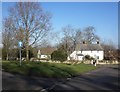
Former post office, Curland
The scene is shown leafless in Image As the sign on the left hints, the triangular green is one-way on its north and west sides. Maps from 1903 to 1993 show the building as a post office, the older ones naming it as Stoneleigh.
Image: © Derek Harper
Taken: 17 Oct 2021
0.13 miles
4
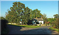
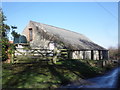
Home of Taunton Town Model Railway Club
Image: © Roger Cornfoot
Taken: 4 Feb 2015
0.20 miles
6
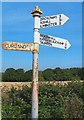
Direction Sign - Signpost on Pound Road northeast of Curland
Pyramid finial - 3 arms; Somerset SCC pyramid by the UC road, in parish of Bickenhall (Taunton Deane District), on the northwest side of a T junction on Pound Lane northeast of Curland.
surveyed
Milestone Society National ID: SO_ST2818
Image: © J Dowding
Taken: Unknown
0.24 miles