IMAGES TAKEN NEAR TO
Creech St. Michael, TAUNTON, TA3 5PT
Introduction
This page details the photographs taken nearby to TA3 5PT by members of the Geograph project.
The Geograph project started in 2005 with the aim of publishing, organising and preserving representative images for every square kilometre of Great Britain, Ireland and the Isle of Man.

There are currently over 7.5m images from over14,400 individuals and you can help contribute to the project by visiting https://www.geograph.org.uk
Image Map
Images are licensed for reuse under creativecommons.org/licenses/by-sa/2.0
Notes
- Clicking on the map will re-center to the selected point.
- The higher the marker number, the further away the image location is from the centre of the postcode.
Image Listing (168 Images Found)
Images are licensed for reuse under creativecommons.org/licenses/by-sa/2.0
Image
Details
Distance
1
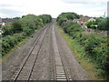
Creech St. Michael Halt railway station (site), Somerset
Opened in 1928 by the Great Western Railway on the line from Bristol to Exeter, the station closed in 1964.
View west towards Taunton and Exeter
Image: © Nigel Thompson
Taken: 8 Jul 2017
0.03 miles
2
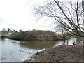
Two Tones
The River Tone carries around the south of Creech St Michael, helping to power some of the old mills that line the area. Here it splits into two and forms a small island. The southern-most line is a modern cutting (to right of shot), reaching to the Tone Bridge before shortly reuniting.
Image: © Neil Owen
Taken: 1 Feb 2023
0.05 miles
3
The view from the narrow road bridge
Looking towards Taunton off the narrow road bridge at Creech St Michael.
Image: © roger geach
Taken: 27 Jul 2008
0.06 miles
4
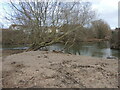
An odd deposit
The River Tone has been severely elevated after heavy rain and splits into two courses here. It was no surprise that the high levels would bring plenty of wash-down and leave some stuff lying around the banks, but this large heap of sand is quite isolated. Could it be someone has dumped it here?
Image: © Neil Owen
Taken: 1 Feb 2023
0.06 miles
5
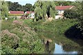
Mill Lane Control Structure
A sluice or two on the old mill leat.
Image: © Neil Owen
Taken: 1 Feb 2023
0.06 miles

7
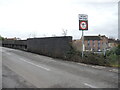
Creech Bridge
Carrying the main road over the railway lines, there is a benchmark on the brick wall beside the signpost. See Image
Image: © Neil Owen
Taken: 1 Feb 2023
0.06 miles
8
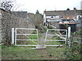
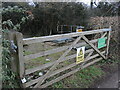
A gate off Laburnham Terrace
A public footpath, with a suitable gap for ambulants and their doggies.
Image: © Neil Owen
Taken: 1 Feb 2023
0.07 miles
9
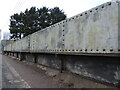
Creech Bridge
Carrying the road over the railway and made in traditional steel rivet style.
Image: © Neil Owen
Taken: 1 Feb 2023
0.07 miles
10
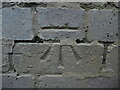
Benchmark on the railway bridge in Creech
A more modern cutmark, as listed in the Benchmark Database: https://www.bench-marks.org.uk/bm144439 , on the brick parapet of the railway bridge. See Image] for a wider view.
Image: © Neil Owen
Taken: 1 Feb 2023
0.07 miles