IMAGES TAKEN NEAR TO
Sycamore Walk, TAUNTON, TA3 5PS
Introduction
This page details the photographs taken nearby to Sycamore Walk, TA3 5PS by members of the Geograph project.
The Geograph project started in 2005 with the aim of publishing, organising and preserving representative images for every square kilometre of Great Britain, Ireland and the Isle of Man.

There are currently over 7.5m images from over14,400 individuals and you can help contribute to the project by visiting https://www.geograph.org.uk
Image Map
Images are licensed for reuse under creativecommons.org/licenses/by-sa/2.0
Notes
- Clicking on the map will re-center to the selected point.
- The higher the marker number, the further away the image location is from the centre of the postcode.
Image Listing (153 Images Found)
Images are licensed for reuse under creativecommons.org/licenses/by-sa/2.0
Image
Details
Distance
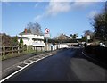
1
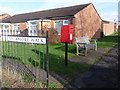
Creech St. Michael: postbox № TA3 600, Sycamore Walk
This postbox, in a small development that appears to be designed with the retired in mind, is emptied at 4:30pm on weekdays and at 10:30am on Saturdays.
Image: © Chris Downer
Taken: 24 Jan 2009
0.02 miles
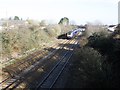
2

Railway bridge & track, Creech St Michael
View from the access road bridge towards the main road bridge over the Paddington - Penzance mainline. The line separates two miles east, one to Bridgwater and Bristol the other via Langport and Westbury. The trackbed looks as if it was originally set out for 2 more lines to allow parallel running in and out of Taunton.
Image: © Crispin Purdye
Taken: 22 Oct 2005
0.02 miles
3
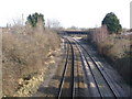
Creech St. Michael: railway passing through
The railway cuts right through the village but trains do not stop.
Image: © Chris Downer
Taken: 24 Jan 2009
0.03 miles
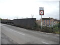
4
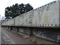
Creech Bridge
Carrying the road over the railway and made in traditional steel rivet style.
Image: © Neil Owen
Taken: 1 Feb 2023
0.04 miles
5
London bound train passes Creech St Michael
Image: © Roger Cornfoot
Taken: 30 Jan 2013
0.05 miles
6
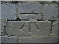
Benchmark on the railway bridge in Creech
A more modern cutmark, as listed in the Benchmark Database: https://www.bench-marks.org.uk/bm144439 , on the brick parapet of the railway bridge. See Image] for a wider view.
Image: © Neil Owen
Taken: 1 Feb 2023
0.05 miles
7
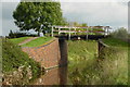
Canal bridge, Creech St Michael
This bridge carries a footpath over the Bridgwater and Taunton Canal, 150m east of the main road bridge in Creech St Michael.
Image: © Crispin Purdye
Taken: 22 Oct 2005
0.05 miles
8
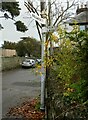
Direction Sign ? Signpost on Bull Street in Creech St Michael parish
Located on the south side of the junction of Bull Street and St Michael Road in Creech St Michael parish. 2 arms and pyramid finial. See also https://www.geograph.org.uk/photo/906413.
Milestone Society National ID: SO_ST2725
Image: © A Rosevear
Taken: 21 Nov 2012
0.06 miles
9
Creech Bridge
Carrying the main road over the railway lines, there is a benchmark on the brick wall beside the signpost. See Image
Image: © Neil Owen
Taken: 1 Feb 2023
0.06 miles