IMAGES TAKEN NEAR TO
Sweeting Close, TAUNTON, TA3 5FB
Introduction
This page details the photographs taken nearby to Sweeting Close, TA3 5FB by members of the Geograph project.
The Geograph project started in 2005 with the aim of publishing, organising and preserving representative images for every square kilometre of Great Britain, Ireland and the Isle of Man.

There are currently over 7.5m images from over14,400 individuals and you can help contribute to the project by visiting https://www.geograph.org.uk
Image Map
Images are licensed for reuse under creativecommons.org/licenses/by-sa/2.0
Notes
- Clicking on the map will re-center to the selected point.
- The higher the marker number, the further away the image location is from the centre of the postcode.
Image Listing (12 Images Found)
Images are licensed for reuse under creativecommons.org/licenses/by-sa/2.0
Image
Details
Distance
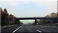
4
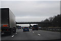
M5 tourist information sign
Approaching Hyde Lane bridge
Image: © Julian P Guffogg
Taken: 9 Aug 2013
0.11 miles
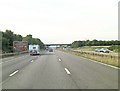
5
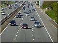
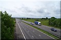
M5 looking North from Hyde Lane bridge
Image: © Michael W Beales BEM
Taken: 23 Apr 2010
0.11 miles
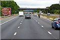
8
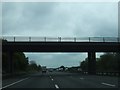
Taunton Deane : M5 Motorway
The M5 Motorway between Junction 25 (Blackbrook Interchange) and Junction 24 (Huntworth Interchange).
Image: © Lewis Clarke
Taken: 30 Sep 2018
0.20 miles
9
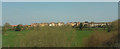
Houses at Creech St Michael
On Derham Close, and slightly obscured by blurred trackside vegetation, these new houses are viewed across the Bridgwater and Taunton Canal.
Image: © Derek Harper
Taken: 1 Apr 2019
0.21 miles
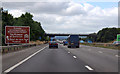
10
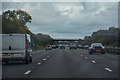
M5 motorway near Creech St. Michael
Looking southwest towards Junction 25,about one mile away.
Image: © Barbara Cook
Taken: 24 May 2006
0.21 miles