IMAGES TAKEN NEAR TO
Stoke St. Mary, TAUNTON, TA3 5BZ
Introduction
This page details the photographs taken nearby to TA3 5BZ by members of the Geograph project.
The Geograph project started in 2005 with the aim of publishing, organising and preserving representative images for every square kilometre of Great Britain, Ireland and the Isle of Man.

There are currently over 7.5m images from over14,400 individuals and you can help contribute to the project by visiting https://www.geograph.org.uk
Image Map
Images are licensed for reuse under creativecommons.org/licenses/by-sa/2.0
Notes
- Clicking on the map will re-center to the selected point.
- The higher the marker number, the further away the image location is from the centre of the postcode.
Image Listing (48 Images Found)
Images are licensed for reuse under creativecommons.org/licenses/by-sa/2.0
Image
Details
Distance
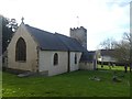
1
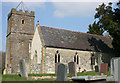
Stoke St Mary Church
View from the south east.
Image: © Nick Chipchase
Taken: 1 Apr 2009
0.04 miles
2
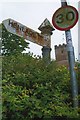
Old Direction Sign - Signpost in Stoke St Mary
Pyramid finial - 1 arm; Somerset SCC pyramid by the UC road, in parish of Stoke St Mary (Taunton Deane District), on the southeast side of a T junction on Stoke Road near the parish church.
surveyed
Milestone Society National ID: SO_ST2622A
Image: © Milestone Society
Taken: Unknown
0.05 miles