IMAGES TAKEN NEAR TO
Badger Street, TAUNTON, TA3 5AZ
Introduction
This page details the photographs taken nearby to Badger Street, TA3 5AZ by members of the Geograph project.
The Geograph project started in 2005 with the aim of publishing, organising and preserving representative images for every square kilometre of Great Britain, Ireland and the Isle of Man.

There are currently over 7.5m images from over14,400 individuals and you can help contribute to the project by visiting https://www.geograph.org.uk
Image Map
Images are licensed for reuse under creativecommons.org/licenses/by-sa/2.0
Notes
- Clicking on the map will re-center to the selected point.
- The higher the marker number, the further away the image location is from the centre of the postcode.
Image Listing (7 Images Found)
Images are licensed for reuse under creativecommons.org/licenses/by-sa/2.0
Image
Details
Distance
1
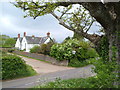
Badger Street
Details at http://webapp1.somerset.gov.uk/her/details.asp?prn=40797 of this C17 farmhouse, seen from the nearby road junction.
Image: © Derek Harper
Taken: 13 May 2006
0.04 miles
2
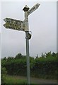
Direction Sign - Signpost by junction in Badger Street
Pyramid finial - 4 arms; Somerset SCC pyramid by the UC road, in parish of Orchard Portman (Taunton Deane District), on the Southeast side of a T-junction at Badger Street.
Surveyed
Milestone Society National ID: SO_ST2619
Image: © Milestone Society
Taken: Unknown
0.06 miles
4
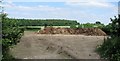
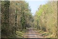
Grove Coppice
From the lane east of Badger Street towards Frost Street.
Image: © Derek Harper
Taken: 13 May 2006
0.14 miles
5
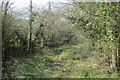
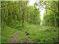
Young Wood
The rougher of a pair of roads that meet here.
Image: © Richard Webb
Taken: 9 Apr 2015
0.17 miles

7
Young Wood
Neroche Estate woodland. A sign states that it is a community woodland and it is used for educational purposes.
Image: © Richard Webb
Taken: 9 Apr 2015
0.19 miles