IMAGES TAKEN NEAR TO
Thurloxton, TAUNTON, TA2 8RJ
Introduction
This page details the photographs taken nearby to TA2 8RJ by members of the Geograph project.
The Geograph project started in 2005 with the aim of publishing, organising and preserving representative images for every square kilometre of Great Britain, Ireland and the Isle of Man.

There are currently over 7.5m images from over14,400 individuals and you can help contribute to the project by visiting https://www.geograph.org.uk
Image Map
Images are licensed for reuse under creativecommons.org/licenses/by-sa/2.0
Notes
- Clicking on the map will re-center to the selected point.
- The higher the marker number, the further away the image location is from the centre of the postcode.
Image Listing (17 Images Found)
Images are licensed for reuse under creativecommons.org/licenses/by-sa/2.0
Image
Details
Distance
1
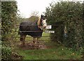
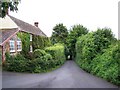
Gate in use, Thurloxton
This gate on Knotcroft Lane in Thurloxton certainly is in use.
Image: © Derek Harper
Taken: 11 Nov 2009
0.04 miles
3
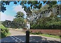
Direction Sign - Signpost in Thurloxton
Located on a grass triangle in the centre of the junction of Mill Lane and Knutscroft Lane in Thurloxton parish. 2 arms and pyramid finial. See also https://www.geograph.org.uk/photo/7831224.
Milestone Society National ID: SO_ST2730B
Image: © Milestone Society
Taken: 1 Jul 2014
0.10 miles
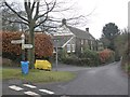
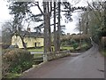
4
Buildings in Thurloxton
Beyond the pair of red stone semis is the village hall. "A village hall for the use of the inhabitants of the parish of Thurloxton without distinction of political, religious or other opinions including use for meetings lectures and classes and for other forms of recreation and leisure-time occupation with the object of improving the conditions of life for the said inhabitants" is how its function is described on the public register of charities. http://www.guidestar.org.uk/gs_summary.aspx?CCReg=290720
Image: © Derek Harper
Taken: 11 Nov 2009
0.10 miles
6
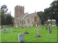
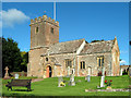
St. Giles church, Thurloxton
Looking NW from the corner of the churchyard
Image: © Martin Southwood
Taken: 27 Apr 2006
0.11 miles
7
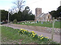
St. Giles' Thurloxton
A pretty setting for this village church. A man is strimming between the gravestones.
Image: © Jonathan Billinger
Taken: 13 Mar 2007
0.13 miles
10
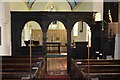
Thurloxton. Church of St.Giles
Rood screen with 3 arches, dated 1734 the middle containing the doorway, a reading and a prayer desk, pulpit in similar style with 4 carved figures and back-panelling. Grade II Listed Church.
Image: © Andrew Riley
Taken: 6 Jun 2018
0.14 miles