IMAGES TAKEN NEAR TO
Kingston St. Mary, TAUNTON, TA2 8JH
Introduction
This page details the photographs taken nearby to TA2 8JH by members of the Geograph project.
The Geograph project started in 2005 with the aim of publishing, organising and preserving representative images for every square kilometre of Great Britain, Ireland and the Isle of Man.

There are currently over 7.5m images from over14,400 individuals and you can help contribute to the project by visiting https://www.geograph.org.uk
Image Map
Images are licensed for reuse under creativecommons.org/licenses/by-sa/2.0
Notes
- Clicking on the map will re-center to the selected point.
- The higher the marker number, the further away the image location is from the centre of the postcode.
Image Listing (22 Images Found)
Images are licensed for reuse under creativecommons.org/licenses/by-sa/2.0
Image
Details
Distance
1
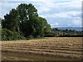
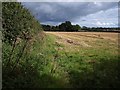
Field near Kingston St Mary
The roofs of buildings in Greenway appear across the corner of Image
Image: © Derek Harper
Taken: 25 Aug 2009
0.11 miles
2
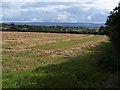
Field near Kingston St Mary
Another view across Image from the same spot, looking to the right, with a view across Taunton Deane to the Blackdown Hills.
Image: © Derek Harper
Taken: 25 Aug 2009
0.13 miles
3
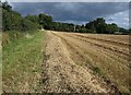
Field near Kingston St Mary
A similar view to Image taken part way along the northern edge, with the wooded grounds of Hillcroft House ahead. The field is on the southernmost slopes of the Quantocks.
Image: © Derek Harper
Taken: 25 Aug 2009
0.17 miles
4
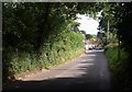
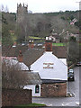
Approaching Kingston St Mary
The lane from Aisholt emerges from a tunnel of trees as it descends from the Quantocks to enter the village. A drainage clearance vehicle is causing some awkwardness for commuter drivers on the bend by the Swan Inn.
Image: © Derek Harper
Taken: 25 Aug 2009
0.18 miles
5
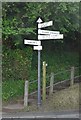
SCC Fingerpost at Kingston St.Mary, Bay Hill
Image: © Andrew Riley
Taken: 6 Jun 2018
0.18 miles
7
Field near Kingston St Mary
Footpath T 15/39 runs along the left side of the field.
Image: © Derek Harper
Taken: 25 Aug 2009
0.19 miles
8
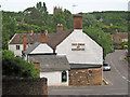
Kingston St. Mary, The Swan with the church in background
Image: © Martin Southwood
Taken: 16 Jan 2006
0.19 miles
9
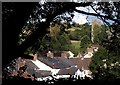
Roofscape, Kingston St Mary
Footpath T 15/41, followed by the West Deane Way, offers glimpses of the village. Image is on the right.
Image: © Derek Harper
Taken: 25 Aug 2009
0.19 miles
10
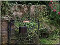
Dogs: please shut the gate
Near Kingston St Mary. Disobedient dogs; the gate was open.
Image: © Derek Harper
Taken: 25 Aug 2009
0.19 miles