IMAGES TAKEN NEAR TO
Kingston St. Mary, TAUNTON, TA2 8HW
Introduction
This page details the photographs taken nearby to TA2 8HW by members of the Geograph project.
The Geograph project started in 2005 with the aim of publishing, organising and preserving representative images for every square kilometre of Great Britain, Ireland and the Isle of Man.

There are currently over 7.5m images from over14,400 individuals and you can help contribute to the project by visiting https://www.geograph.org.uk
Image Map
Images are licensed for reuse under creativecommons.org/licenses/by-sa/2.0
Notes
- Clicking on the map will re-center to the selected point.
- The higher the marker number, the further away the image location is from the centre of the postcode.
Image Listing (127 Images Found)
Images are licensed for reuse under creativecommons.org/licenses/by-sa/2.0
Image
Details
Distance
1
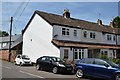
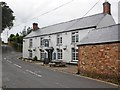
Kingston St.Mary
Row of Cottages next to The Swan.
Image: © Andrew Riley
Taken: 6 Jun 2018
0.01 miles
2
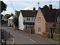
Kingston St Mary
The buildings on the right of the view in Image The furthest of the three is The Swan pub. On the right is the C16-C17 Bobbetts, formerly a farmhouse http://www.tauntondeane.gov.uk/tdbcsites/her/her_lb/lbdets.asp?id=000273 . In between is the end of a row of cottages at an angle to the road.
Image: © Derek Harper
Taken: 25 Aug 2009
0.01 miles
4
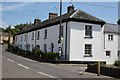
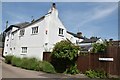
Kingston St.Mary
The Coneys. Grade II Listed. Early 19th Century.
Image: © Andrew Riley
Taken: 6 Jun 2018
0.02 miles
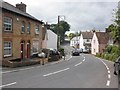
6

The Swan, Kingston St Mary
The pub straddles a gridline, so the very left-hand end is in Image
Image: © Derek Harper
Taken: 25 Aug 2009
0.03 miles
7

The Swan, Kingston St Mary
Image seen from the start of footpath T 15/41 to Parsonage Lane, with a signpost in the foreground. Most of the pub is on the far side of a gridline.
Image: © Derek Harper
Taken: 25 Aug 2009
0.03 miles
9
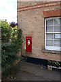
Post box, Kingston St Mary
The brick building (which appears on the extreme left of Image) was until recently the post office, and is still shown as such on maps. The George V postbox bears a notice "this box is now closed".
Image: © Derek Harper
Taken: 25 Aug 2009
0.03 miles
10
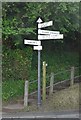
SCC Fingerpost at Kingston St.Mary, Bay Hill
Image: © Andrew Riley
Taken: 6 Jun 2018
0.04 miles