IMAGES TAKEN NEAR TO
Chantry Close, TAUNTON, TA2 8EN
Introduction
This page details the photographs taken nearby to Chantry Close, TA2 8EN by members of the Geograph project.
The Geograph project started in 2005 with the aim of publishing, organising and preserving representative images for every square kilometre of Great Britain, Ireland and the Isle of Man.

There are currently over 7.5m images from over14,400 individuals and you can help contribute to the project by visiting https://www.geograph.org.uk
Image Map
Images are licensed for reuse under creativecommons.org/licenses/by-sa/2.0
Notes
- Clicking on the map will re-center to the selected point.
- The higher the marker number, the further away the image location is from the centre of the postcode.
Image Listing (47 Images Found)
Images are licensed for reuse under creativecommons.org/licenses/by-sa/2.0
Image
Details
Distance
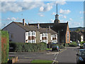
2
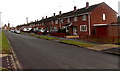
Buckland Road houses, Taunton
From the corner of Eastwick Road.
Image: © Jaggery
Taken: 16 Dec 2014
0.07 miles
3
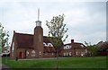
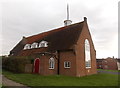
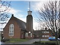
St. Teresa of Lisieux
This Roman Catholic Church was built at the same time as the Priorswood (housing) Estate. The smaller building to the right side is accommodation for the clergy.
Although the usual spelling is St. Theresa, the "h" seems to be missing in this case.
Image: © Barbara Cook
Taken: 6 May 2006
0.07 miles
4
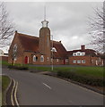
North side of St Theresa's Catholic Church, Taunton
Church in the Roman Catholic Diocese of Clifton, viewed from Eastwick Road.
http://www.geograph.org.uk/photo/4281122 to a view of the south side.
Image: © Jaggery
Taken: 16 Dec 2014
0.11 miles
5
St Theresa's Catholic Church, Taunton
Church in the Roman Catholic Diocese of Clifton, viewed across Eastwick Road.
Image: © Jaggery
Taken: 16 Dec 2014
0.11 miles
6
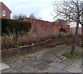
Buckland Road electricity substation, Taunton
Located in a brick enclosure near the corner of Buckland Road and Eastwick Road.
Beneath the yellow Western Power Distribution notice on door in the wall,
the identifier shows BUCKLAND ROAD SW STATION T0692.
Image: © Jaggery
Taken: 16 Dec 2014
0.12 miles
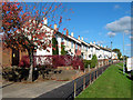
7
Lyngford Road houses, Taunton
Looking like one long row from this angle, the houses are in several rows, with garages in between.
St Theresa's Catholic Church http://www.geograph.org.uk/photo/4281122 in Eastwick Road is in the background.
Image: © Jaggery
Taken: 16 Dec 2014
0.12 miles
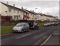
8

Lyngford Road towards Eastwick Road, Taunton
Viewed from the corner of Victory Road.
Image: © Jaggery
Taken: 16 Dec 2014
0.12 miles
9
St Theresa's Catholic Church, Priorswood
Image: © Roger Cornfoot
Taken: 5 Feb 2014
0.12 miles