IMAGES TAKEN NEAR TO
Kingston Road, TAUNTON, TA2 7SJ
Introduction
This page details the photographs taken nearby to Kingston Road, TA2 7SJ by members of the Geograph project.
The Geograph project started in 2005 with the aim of publishing, organising and preserving representative images for every square kilometre of Great Britain, Ireland and the Isle of Man.

There are currently over 7.5m images from over14,400 individuals and you can help contribute to the project by visiting https://www.geograph.org.uk
Image Map
Images are licensed for reuse under creativecommons.org/licenses/by-sa/2.0
Notes
- Clicking on the map will re-center to the selected point.
- The higher the marker number, the further away the image location is from the centre of the postcode.
Image Listing (60 Images Found)
Images are licensed for reuse under creativecommons.org/licenses/by-sa/2.0
Image
Details
Distance
1

Modern Milestone by Kingston Road, Staplegrove, Taunton parish
Metal plate attached to stone post by the UC road, in parish of TAUNTON (TAUNTON DEANE District), Staplegrove, by Northway House, Kingston Road, against wall in pavement, on East side of road. CERDIC new Taunton iron plate, erected by the County Council in the 21st century.
Inscription reads:-
1
MILES
To
Taunton
Maker:-
CERDIC 2007
Milestone Society National ID: SO_TAKM01
Image: © Alan Rosevear
Taken: 6 May 2011
0.07 miles
2
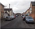
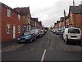
Peter Street, Taunton
From the Cheddon Road end looking along Peter Street towards Ethpark Grove.
Image: © Jaggery
Taken: 16 Dec 2014
0.07 miles
3
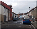
Portman Street, Taunton
Viewed from the Cheddon Road end. Fencing on the right is at the edge of a construction site. http://www.geograph.org.uk/photo/4287545
Image: © Jaggery
Taken: 16 Dec 2014
0.08 miles
4
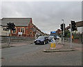
A358 Greenway Road at Kingston Rd junction
Image: © Peter Turner
Taken: 5 Sep 2016
0.08 miles
5
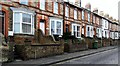
Terraced houses in Greenway Road, Taunton
Image: © nick macneill
Taken: 15 Mar 2013
0.08 miles
6
George Street Taunton
Looking WNW from the Cheddon Road end.
Image: © Jaggery
Taken: 16 Dec 2014
0.10 miles
7
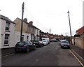
Vera Street, Taunton
A dead-end street on the west side of Cheddon Road.
Image: © Jaggery
Taken: 16 Dec 2014
0.11 miles
8
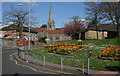
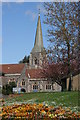
St. Andrew's Church
St Andrew's club room on right. The gardens in the foreground are where Rowbarton Chapel once stood.
Image: © Nick Chipchase
Taken: 13 Apr 2009
0.11 miles
10
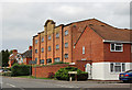
A striking building amongst the semis of Kingston Road
The erstwhile Hatchers Depositories now desirable dwellings.
Image: © Peter Turner
Taken: 6 Sep 2016
0.13 miles