IMAGES TAKEN NEAR TO
Cheddon Road, TAUNTON, TA2 7QU
Introduction
This page details the photographs taken nearby to Cheddon Road, TA2 7QU by members of the Geograph project.
The Geograph project started in 2005 with the aim of publishing, organising and preserving representative images for every square kilometre of Great Britain, Ireland and the Isle of Man.

There are currently over 7.5m images from over14,400 individuals and you can help contribute to the project by visiting https://www.geograph.org.uk
Image Map
Images are licensed for reuse under creativecommons.org/licenses/by-sa/2.0
Notes
- Clicking on the map will re-center to the selected point.
- The higher the marker number, the further away the image location is from the centre of the postcode.
Image Listing (8 Images Found)
Images are licensed for reuse under creativecommons.org/licenses/by-sa/2.0
Image
Details
Distance
1
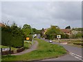
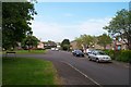
Cheddon Road, Taunton
On the northern edge of Taunton with a housing estate on the left and farmland on the right.
Image: © Robin Drayton
Taken: 13 May 2013
0.01 miles
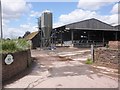
6
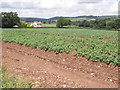
Potato field, near Cheddon Fitzpaine
Image: © Roger Cornfoot
Taken: 15 Jun 2013
0.21 miles
7
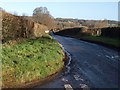
Lyngford Lane approaching Rowford
The lane has emerged from the housing estates of northern Taunton and here, by the junction with a lane to Upper Cheddon, drops towards the hamlet of Rowford and a small tributary of the River Tone. The distant mansion on the hillside is Hestercombe House, in Image
Image: © Derek Harper
Taken: 17 Jan 2009
0.24 miles
8
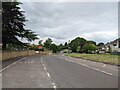
Bus stop on Cheddon Road at Wellsprings Leisure Centre
Image: © Rob Purvis
Taken: 28 Jun 2023
0.24 miles