IMAGES TAKEN NEAR TO
Draycott Avenue, TAUNTON, TA2 7QG
Introduction
This page details the photographs taken nearby to Draycott Avenue, TA2 7QG by members of the Geograph project.
The Geograph project started in 2005 with the aim of publishing, organising and preserving representative images for every square kilometre of Great Britain, Ireland and the Isle of Man.

There are currently over 7.5m images from over14,400 individuals and you can help contribute to the project by visiting https://www.geograph.org.uk
Image Map
Images are licensed for reuse under creativecommons.org/licenses/by-sa/2.0
Notes
- Clicking on the map will re-center to the selected point.
- The higher the marker number, the further away the image location is from the centre of the postcode.
Image Listing (76 Images Found)
Images are licensed for reuse under creativecommons.org/licenses/by-sa/2.0
Image
Details
Distance
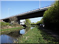
1
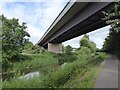
Under the A358 by the Bridgwater and Taunton Canal
Image: © David Smith
Taken: 12 Jun 2017
0.13 miles
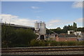
2
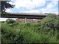
A358 bridge over Bridgwater and Taunton Canal
Image: © David Smith
Taken: 12 Jun 2017
0.13 miles
3
Bridge, carrying the A358 over the Bridgwater Canal
Image: © Roger Cornfoot
Taken: 8 Apr 2011
0.13 miles
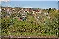
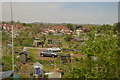
7
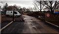
Muddy entrance to a Lyngford Road building site, Taunton
Viewed in December 2014. The entrance leads into the former site of Taunton Academy which has relocated to a new site in Cheddon Road. The site safety notice on the right is headed RGSPILLER.
Image: © Jaggery
Taken: 16 Dec 2014
0.15 miles