IMAGES TAKEN NEAR TO
Hereford Drive, TAUNTON, TA2 7JX
Introduction
This page details the photographs taken nearby to Hereford Drive, TA2 7JX by members of the Geograph project.
The Geograph project started in 2005 with the aim of publishing, organising and preserving representative images for every square kilometre of Great Britain, Ireland and the Isle of Man.

There are currently over 7.5m images from over14,400 individuals and you can help contribute to the project by visiting https://www.geograph.org.uk
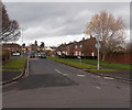
Image Map
Images are licensed for reuse under creativecommons.org/licenses/by-sa/2.0
Notes
- Clicking on the map will re-center to the selected point.
- The higher the marker number, the further away the image location is from the centre of the postcode.
Image Listing (30 Images Found)
Images are licensed for reuse under creativecommons.org/licenses/by-sa/2.0
Image
Details
Distance
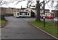
1
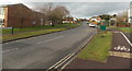
Dorchester Road, Taunton
Looking NNW from the corner of Eastwick Road.
Image: © Jaggery
Taken: 16 Dec 2014
0.08 miles
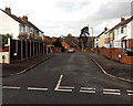
2
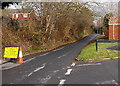
Lyngford Lane closed for most of December 2014, Taunton
The Wales & West Utilities sign faces Dorchester Road.
Image: © Jaggery
Taken: 16 Dec 2014
0.15 miles
4
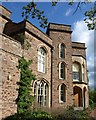
Lyngford House
A side view of the house http://webapp1.somerset.gov.uk/her/details.asp?prn=40491 shown in Image; see also http://www.lyngford-house.co.uk/ .
Image: © Derek Harper
Taken: 16 Apr 2011
0.16 miles
5
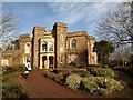
Lyngford House
Now a conference centre within the suburbs of Taunton, this country house dates from about 1830. It has distinctive Gothic touches and canted towers on either side of the west porch. "The first recorded occupant, John Roy Allen married 1831 Miss Watson of Bath and the house was probably built for them" http://webapp1.somerset.gov.uk/her/details.asp?prn=40491 .
Image: © Derek Harper
Taken: 16 Jan 2010
0.16 miles
6
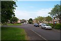
Corey Road, Taunton
Viewed from Eastwick Road looking north along Cory Road towards St Michael's Crescent.
Image: © Jaggery
Taken: 16 Dec 2014
0.16 miles
7
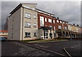
Dorchester House, Taunton
Flats in Priorswood Place, near the corner of Dorchester Road and Lyngford Lane.
Image: © Jaggery
Taken: 16 Dec 2014
0.17 miles
8
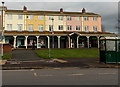
Co-operative Pharmacy and Food store, Priorswood Place, Taunton
On the Dorchester Road side of Priorswood Place,
Co-operative Pharmacy is on the left, Co-operative Food store on the right.
Image: © Jaggery
Taken: 16 Dec 2014
0.17 miles
9
Selworthy Road, Taunton
Viewed from Eastwick Road.
Image: © Jaggery
Taken: 16 Dec 2014
0.17 miles
10
The Waggon, Taunton
Pub set back 50 metres from the west side of Dorchester Road, near the Eastwick Road junction.
Image: © Jaggery
Taken: 16 Dec 2014
0.18 miles