IMAGES TAKEN NEAR TO
Stembridge Way, TAUNTON, TA2 6SX
Introduction
This page details the photographs taken nearby to Stembridge Way, TA2 6SX by members of the Geograph project.
The Geograph project started in 2005 with the aim of publishing, organising and preserving representative images for every square kilometre of Great Britain, Ireland and the Isle of Man.

There are currently over 7.5m images from over14,400 individuals and you can help contribute to the project by visiting https://www.geograph.org.uk
Image Map
Images are licensed for reuse under creativecommons.org/licenses/by-sa/2.0
Notes
- Clicking on the map will re-center to the selected point.
- The higher the marker number, the further away the image location is from the centre of the postcode.
Image Listing (28 Images Found)
Images are licensed for reuse under creativecommons.org/licenses/by-sa/2.0
Image
Details
Distance
1
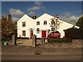
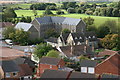
United Reformed Church, Norton Fitzwarren
Built in 1821 as a Congregational Church, together with the Manse (the left-hand part). This is the home of the South Western Synod (one of 13 in Great Britain) of the United Reformed Church. Architectural information at http://www.tauntondeane.gov.uk/tdbcsites/her/her_lb/lbdets.asp?id=000315 Seen from across the B3227.
Image: © Derek Harper
Taken: 9 Oct 2008
0.12 miles
2
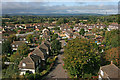
Norton Fitzwarren
View from church tower.
Image: © Nick Chipchase
Taken: 12 Oct 2011
0.13 miles
3

Norton Fitzwarren : Field & Tree
A tree in the field.
Image: © Lewis Clarke
Taken: 16 Jan 2023
0.14 miles
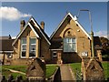
4
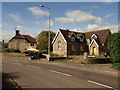
Former school, Norton Fitzwarren
On the right, by the junction of the B3227 and Rectory Road, is the former Manor School, now residential accommodation.
Image: © Derek Harper
Taken: 9 Oct 2008
0.14 miles
5
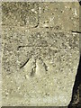
Ordnance Survey Cut Mark
This OS cut mark can be found on the old Manor School building. It marks a point 24.570m above mean sea level.
Image: © Adrian Dust
Taken: 9 Feb 2015
0.15 miles
6
Norton Fitzwarren
View of the old village club.
Image: © Nick Chipchase
Taken: 12 Oct 2011
0.17 miles
7

Norton Fitzwarren : Field
A crop field in the countryside.
Image: © Lewis Clarke
Taken: 16 Jan 2023
0.17 miles
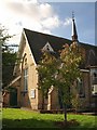
8
United Reformed Church, Norton Fitzwarren
Image: © Roger Cornfoot
Taken: 1 Nov 2010
0.17 miles
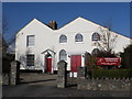
9
Village hall, Norton Fitzwarren
Built in 1896 as the Village Social Club, this is at the corner of Station Road and the B3227.
Image: © Derek Harper
Taken: 9 Oct 2008
0.19 miles
10
Village hall, Norton Fitzwarren
A view of Image as it faces Station Road, with the words "village club" proudly standing out.
Image: © Derek Harper
Taken: 9 Oct 2008
0.19 miles