IMAGES TAKEN NEAR TO
Manor Drive, TAUNTON, TA2 6AR
Introduction
This page details the photographs taken nearby to Manor Drive, TA2 6AR by members of the Geograph project.
The Geograph project started in 2005 with the aim of publishing, organising and preserving representative images for every square kilometre of Great Britain, Ireland and the Isle of Man.

There are currently over 7.5m images from over14,400 individuals and you can help contribute to the project by visiting https://www.geograph.org.uk
Image Map
Images are licensed for reuse under creativecommons.org/licenses/by-sa/2.0
Notes
- Clicking on the map will re-center to the selected point.
- The higher the marker number, the further away the image location is from the centre of the postcode.
Image Listing (32 Images Found)
Images are licensed for reuse under creativecommons.org/licenses/by-sa/2.0
Image
Details
Distance

2
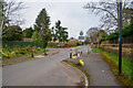
Taunton : Manor Road
In the Staplegrove area of Taunton.
Image: © Lewis Clarke
Taken: 9 Mar 2019
0.03 miles
3
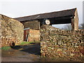
Outbuilding, Pomeroy's Farm, Staplegrove
Image: © Roger Cornfoot
Taken: 5 Feb 2014
0.08 miles
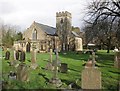
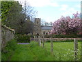
4

The Church of St John the Evangelist, Staplegrove
The church has its origins in the 13th century, with restoration being carried out in 1857 and 1873. The church was enlarged in 1961.
Image: © Maigheach-gheal
Taken: 7 May 2010
0.09 miles
5
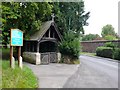
St John The Evangelist, Staplegrove
The church of St John the Evangelist in Staplegrove dates back to the 13th century. Although there has been much restoration, especially during the 19th and 20th centuries, a significant amount of the early stonework remains. The lych gate opens on to the minor road from Westerkirk to Wellsprings which at this point is part of the West Deane Way
Image: © Nigel Mykura
Taken: 1 Aug 2009
0.09 miles
6

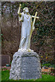
Chest tomb, The Church of St John the Evangelist
The late 16th century sandstone chest tomb is to be found to the south of the church porch.
Image: © Maigheach-gheal
Taken: 7 May 2010
0.10 miles
7
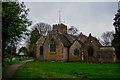
Taunton : St John the Evangelist
GV II Parish church. C13 chancel arch, lower stage of tower, some C15 work but mostly of the 1857 and 1873 restoration when vestry and North aisle added, porch 1902, enlarged 1961 - https://historicengland.org.uk/listing/the-list/list-entry/1060479
Image: © Lewis Clarke
Taken: 9 Mar 2019
0.10 miles
8
Taunton : St John the Evangelist Churchyard
A headstone for Ellie Charlotte Isabelle Tripp and Charles Llewellyn Howard Tripp.
Image: © Lewis Clarke
Taken: 9 Mar 2019
0.11 miles
9
Church of St John the Evangelist, Staplegrove
Image: © Roger Cornfoot
Taken: 5 Feb 2014
0.11 miles
10
Channel to Channel (363)
This green track leads to Manor Road.
Image: © Shazz
Taken: 26 Apr 2015
0.11 miles