IMAGES TAKEN NEAR TO
Hawthorn Road, MINEHEAD, TA24 8EP
Introduction
This page details the photographs taken nearby to Hawthorn Road, TA24 8EP by members of the Geograph project.
The Geograph project started in 2005 with the aim of publishing, organising and preserving representative images for every square kilometre of Great Britain, Ireland and the Isle of Man.

There are currently over 7.5m images from over14,400 individuals and you can help contribute to the project by visiting https://www.geograph.org.uk
Image Map (Loading...)


Getting Data...Please wait
Leaflet Map data © OpenStreetMap
Images are licensed for reuse under creativecommons.org/licenses/by-sa/2.0
Notes
- Clicking on the map will re-center to the selected point.
- The higher the marker number, the further away the image location is from the centre of the postcode.
Image Listing (33 Images Found)
Images are licensed for reuse under creativecommons.org/licenses/by-sa/2.0
Image
Details
Distance
2
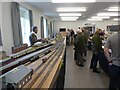
Model railway exhibition at Sainsbury Hall
Image: © Roger Cornfoot
Taken: 30 Oct 2021
0.05 miles
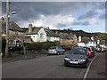

6
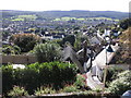
View towards Periton, from St Michael's Church
Image: © Roger Cornfoot
Taken: 26 Sep 2010
0.09 miles

8

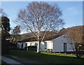
Large stone villa, Woodcombe, Minehead
Image: © Roger Cornfoot
Taken: 30 Dec 2012
0.12 miles
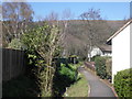
9
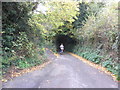
Periton Lane
Leading from Minehead to the old village of Periton - now engulfed by the town.
Image: © Roger Cornfoot
Taken: 2 Nov 2010
0.13 miles