IMAGES TAKEN NEAR TO
Periton Rise, MINEHEAD, TA24 8EH
Introduction
This page details the photographs taken nearby to Periton Rise, TA24 8EH by members of the Geograph project.
The Geograph project started in 2005 with the aim of publishing, organising and preserving representative images for every square kilometre of Great Britain, Ireland and the Isle of Man.

There are currently over 7.5m images from over14,400 individuals and you can help contribute to the project by visiting https://www.geograph.org.uk
Image Map
Images are licensed for reuse under creativecommons.org/licenses/by-sa/2.0
Notes
- Clicking on the map will re-center to the selected point.
- The higher the marker number, the further away the image location is from the centre of the postcode.
Image Listing (29 Images Found)
Images are licensed for reuse under creativecommons.org/licenses/by-sa/2.0
Image
Details
Distance
1
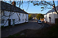
Minehead : Periton Lane
A small residential road in Minehead.
Image: © Lewis Clarke
Taken: 2 May 2016
0.04 miles
4
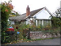
The Lidgetts, Periton Lane
Nature appears to be reclaiming this bungalow.
Image: © Roger Cornfoot
Taken: 2 Nov 2010
0.05 miles
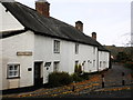
5

Minehead : House
A house for sale near Periton Lane.
Image: © Lewis Clarke
Taken: 2 May 2016
0.07 miles
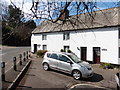
7
Electricity substation, Periton Cross
Image: © Roger Cornfoot
Taken: 2 Nov 2010
0.07 miles
8
Brook, surfacing briefly on Periton Lane
Image: © Roger Cornfoot
Taken: 31 Mar 2020
0.07 miles
9

Minehead : Residential Drive
A driveway off of the A39 to these bungalows.
Image: © Lewis Clarke
Taken: 2 May 2016
0.08 miles
10
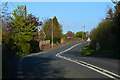
Minehead : The A39
Heading along the A39 road.
Image: © Lewis Clarke
Taken: 2 May 2016
0.08 miles