IMAGES TAKEN NEAR TO
West Park Close, MINEHEAD, TA24 8BB
Introduction
This page details the photographs taken nearby to West Park Close, TA24 8BB by members of the Geograph project.
The Geograph project started in 2005 with the aim of publishing, organising and preserving representative images for every square kilometre of Great Britain, Ireland and the Isle of Man.

There are currently over 7.5m images from over14,400 individuals and you can help contribute to the project by visiting https://www.geograph.org.uk
Image Map
Images are licensed for reuse under creativecommons.org/licenses/by-sa/2.0
Notes
- Clicking on the map will re-center to the selected point.
- The higher the marker number, the further away the image location is from the centre of the postcode.
Image Listing (33 Images Found)
Images are licensed for reuse under creativecommons.org/licenses/by-sa/2.0
Image
Details
Distance
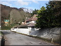
1
Periton Lane
Leading from Minehead to the old village of Periton - now engulfed by the town.
Image: © Roger Cornfoot
Taken: 2 Nov 2010
0.06 miles
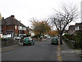
4
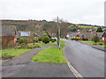
West Park, Minehead
One of the residential streets on the western side of the town.
Taken from the south east corner of the grid square looking north.
The wood on the hill in the background is Woodcombe Brake.
Image: © David P Howard
Taken: 10 Feb 2013
0.09 miles
5
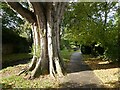
Mature Poplar tree in 'The Parks', Minehead
Image: © Roger Cornfoot
Taken: 30 Oct 2021
0.10 miles
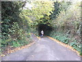
6
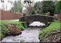
Brook & Footbridge, The Parks, Minehead
A quite fast-flowing brook flows through "The Parks" on the western side of Minehead; this little bridge carries the footpath over it. Another bridge over this brook can be seen here Image]
Image: © Rob Farrow
Taken: 31 Dec 2006
0.10 miles
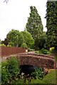
8
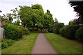
The Parks Walk in Minehead
The Parks Walk follows the Bratton Stream into Minehead.
Image: © Steve Daniels
Taken: 21 May 2011
0.10 miles