IMAGES TAKEN NEAR TO
Rodhuish, MINEHEAD, TA24 6QU
Introduction
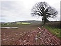
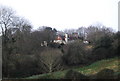
This page details the photographs taken nearby to TA24 6QU by members of the Geograph project.
The Geograph project started in 2005 with the aim of publishing, organising and preserving representative images for every square kilometre of Great Britain, Ireland and the Isle of Man.

There are currently over 7.5m images from over14,400 individuals and you can help contribute to the project by visiting https://www.geograph.org.uk
Image Map
Images are licensed for reuse under creativecommons.org/licenses/by-sa/2.0
Notes
- Clicking on the map will re-center to the selected point.
- The higher the marker number, the further away the image location is from the centre of the postcode.
Image Listing (23 Images Found)
Images are licensed for reuse under creativecommons.org/licenses/by-sa/2.0
Image
Details
Distance
5
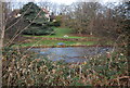
Lake in the grounds of Golsoncott House
The lake is in this grid square the house is in the next square north.
Image: © N Chadwick
Taken: 28 Dec 2009
0.17 miles
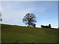
8
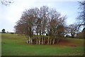
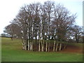
Clump of trees in the grounds of Croydon Hall
Image: © N Chadwick
Taken: 28 Dec 2009
0.17 miles