IMAGES TAKEN NEAR TO
Mill Street, MINEHEAD, TA24 6QD
Introduction
This page details the photographs taken nearby to Mill Street, TA24 6QD by members of the Geograph project.
The Geograph project started in 2005 with the aim of publishing, organising and preserving representative images for every square kilometre of Great Britain, Ireland and the Isle of Man.

There are currently over 7.5m images from over14,400 individuals and you can help contribute to the project by visiting https://www.geograph.org.uk
Image Map (Loading...)


Getting Data...Please wait
Leaflet Map data © OpenStreetMap
Images are licensed for reuse under creativecommons.org/licenses/by-sa/2.0
Notes
- Clicking on the map will re-center to the selected point.
- The higher the marker number, the further away the image location is from the centre of the postcode.
Image Listing (9 Images Found)
Images are licensed for reuse under creativecommons.org/licenses/by-sa/2.0
Image
Details
Distance
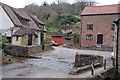
2
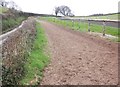
Withycombe Ford
This ford is found at the bottom of Rattle Row at Withycombe.
Image: © John Walton
Taken: 19 Sep 2016
0.02 miles
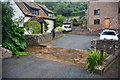
5
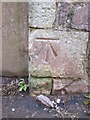
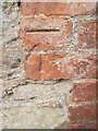
Ordnance Survey Cut Mark
This OS cut mark can be found on the wall of the old School. It marks a point 59.023m above mean sea level.
Image: © Adrian Dust
Taken: 18 May 2015
0.05 miles
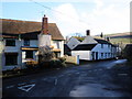
6
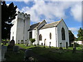
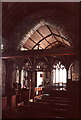
WITHYCOMBE, Somerset
The church of St Nicholas
Image: © ChurchCrawler
Taken: 14 Sep 2005
0.06 miles
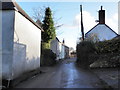
9
Ordnance Survey Cut Mark
This OS cut mark can be found on a barn on the west side of the road at Court Place Farm. It marks a point 51.835m above mean sea level.
Image: © Adrian Dust
Taken: 18 May 2015
0.24 miles