IMAGES TAKEN NEAR TO
Old Cleeve, MINEHEAD, TA24 6HS
Introduction
This page details the photographs taken nearby to TA24 6HS by members of the Geograph project.
The Geograph project started in 2005 with the aim of publishing, organising and preserving representative images for every square kilometre of Great Britain, Ireland and the Isle of Man.

There are currently over 7.5m images from over14,400 individuals and you can help contribute to the project by visiting https://www.geograph.org.uk
Image Map
Images are licensed for reuse under creativecommons.org/licenses/by-sa/2.0
Notes
- Clicking on the map will re-center to the selected point.
- The higher the marker number, the further away the image location is from the centre of the postcode.
Image Listing (44 Images Found)
Images are licensed for reuse under creativecommons.org/licenses/by-sa/2.0
Image
Details
Distance
5
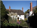
Old Cleeve Farm
Owned by the Crown Estate.
Image: © Roger Cornfoot
Taken: 16 Oct 2010
0.09 miles
6
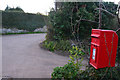
Old Cleeve : Post Box & Road
A road with the post box in view in Old Cleeve.
Image: © Lewis Clarke
Taken: 9 Apr 2016
0.10 miles
7
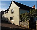
Cat sitting in the Autumn sunshine at Orchard House
Image: © Roger Cornfoot
Taken: 13 Nov 2016
0.10 miles
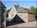
8
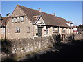
The Lysacht Club and Community Hall, Old Cleeve
Image: © Roger Cornfoot
Taken: 16 Oct 2010
0.10 miles
9
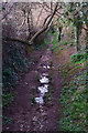
West Somerset : Footpath
A footpath heading away from Old Cleeve.
Image: © Lewis Clarke
Taken: 9 Apr 2016
0.11 miles