IMAGES TAKEN NEAR TO
Orchard Court, Manor Road, MINEHEAD, TA24 6ES
Introduction
This page details the photographs taken nearby to Orchard Court, Manor Road, TA24 6ES by members of the Geograph project.
The Geograph project started in 2005 with the aim of publishing, organising and preserving representative images for every square kilometre of Great Britain, Ireland and the Isle of Man.

There are currently over 7.5m images from over14,400 individuals and you can help contribute to the project by visiting https://www.geograph.org.uk
Image Map (Loading...)


Getting Data...Please wait
Leaflet Map data © OpenStreetMap
Images are licensed for reuse under creativecommons.org/licenses/by-sa/2.0
Notes
- Clicking on the map will re-center to the selected point.
- The higher the marker number, the further away the image location is from the centre of the postcode.
Image Listing (62 Images Found)
Images are licensed for reuse under creativecommons.org/licenses/by-sa/2.0
Image
Details
Distance
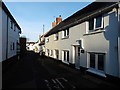
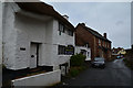
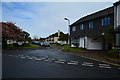
1
Minehead : Manor Road
Looking along Manor Road as it heads out from Minehead.
Image: © Lewis Clarke
Taken: 2 May 2016
0.01 miles
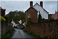
2
Minehead : Cefn Court
A small path and alleyway off of Manor Road.
Image: © Lewis Clarke
Taken: 2 May 2016
0.03 miles
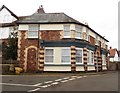
3

Minehead : Manor Road
The Britannia Pub seen here on the right.
Image: © Lewis Clarke
Taken: 2 May 2016
0.03 miles
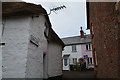
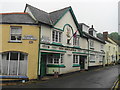
4
'The Stores', Alcombe
Former shop premises.
Image: © Roger Cornfoot
Taken: 8 Mar 2019
0.03 miles
5
Minehead : Manor Road
A small road on the outskirts of Minehead.
Image: © Lewis Clarke
Taken: 2 May 2016
0.03 miles
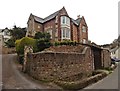
8
Minehead : The Close
A residential road off of Church Street.
Image: © Lewis Clarke
Taken: 2 May 2016
0.05 miles
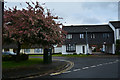
9
Minehead : The Close
A residential road off of Church Street. Raglan Lodge is to the right.
Image: © Lewis Clarke
Taken: 2 May 2016
0.05 miles