IMAGES TAKEN NEAR TO
Alcombe Road, MINEHEAD, TA24 6AZ
Introduction
This page details the photographs taken nearby to Alcombe Road, TA24 6AZ by members of the Geograph project.
The Geograph project started in 2005 with the aim of publishing, organising and preserving representative images for every square kilometre of Great Britain, Ireland and the Isle of Man.

There are currently over 7.5m images from over14,400 individuals and you can help contribute to the project by visiting https://www.geograph.org.uk
Image Map (Loading...)


Getting Data...Please wait
Leaflet Map data © OpenStreetMap
Images are licensed for reuse under creativecommons.org/licenses/by-sa/2.0
Notes
- Clicking on the map will re-center to the selected point.
- The higher the marker number, the further away the image location is from the centre of the postcode.
Image Listing (65 Images Found)
Images are licensed for reuse under creativecommons.org/licenses/by-sa/2.0
Image
Details
Distance
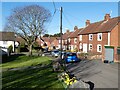
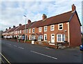
3

Minehead : Hopcott Road Houses
Houses on Hopcott Road in Minehead.
Image: © Lewis Clarke
Taken: 2 May 2016
0.06 miles
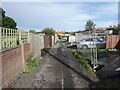
4

Marley Close, Minehead
Built on the site of the former Marley Tile works.
Image: © Roger Cornfoot
Taken: 16 Mar 2021
0.06 miles
6
Former Convenience store, Alcombe
By 2016 this site had been unoccupied for 4 years.
Image: © Roger Cornfoot
Taken: 2 May 2016
0.06 miles
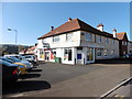
8
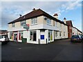
Former convenience store, Alcombe
Still no takers after 8 years!
Image: © Roger Cornfoot
Taken: 7 Jan 2021
0.07 miles
9
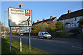
Minehead : Hopcott Road, A39
Looking along Hopcott Road as it heads through Minehead.
Image: © Lewis Clarke
Taken: 2 May 2016
0.07 miles
10
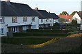
Minehead : Marley Close
Houses and hedgerows at Marley Close.
Image: © Lewis Clarke
Taken: 2 May 2016
0.08 miles