IMAGES TAKEN NEAR TO
Vicarage Road, MINEHEAD, TA24 5RP
Introduction
This page details the photographs taken nearby to Vicarage Road, TA24 5RP by members of the Geograph project.
The Geograph project started in 2005 with the aim of publishing, organising and preserving representative images for every square kilometre of Great Britain, Ireland and the Isle of Man.

There are currently over 7.5m images from over14,400 individuals and you can help contribute to the project by visiting https://www.geograph.org.uk
Image Map (Loading...)


Getting Data...Please wait
Leaflet Map data © OpenStreetMap
Images are licensed for reuse under creativecommons.org/licenses/by-sa/2.0
Notes
- Clicking on the map will re-center to the selected point.
- The higher the marker number, the further away the image location is from the centre of the postcode.
Image Listing (169 Images Found)
Images are licensed for reuse under creativecommons.org/licenses/by-sa/2.0
Image
Details
Distance
1
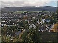
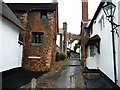
Minehead : Town Scenery
From the churchyard looking down into the town's suburbs.
Image: © Lewis Clarke
Taken: 3 Nov 2023
0.01 miles
2
Minehead : Vicarage Road
Looking along Vicarage Road with St Michael's Church on the hillside.
Image: © Lewis Clarke
Taken: 18 Apr 2014
0.01 miles
3
Minehead : Vicarage Road
Looking along Vicarage Road in Minehead.
Image: © Lewis Clarke
Taken: 18 Apr 2014
0.01 miles
4
Willow Cottage
This thatched dwelling (one of several in this area) is Willow Cottage - a fifteenth century open hearth house, restored in 1985.
See Image] for the cottages at the top of the hill.
Image: © Neil Owen
Taken: 25 Jun 2013
0.02 miles
5
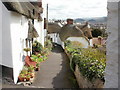
Church Steps - Higher Town
The Higher Town area of Minehead is located on the lower slopes of North Hill, and is the older, more picturesque part of the town. Predictably climb up towards the parish church which commands a fine view.
Image: © Phil Champion
Taken: 16 Jul 2009
0.02 miles
6
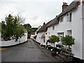
Cottages on Vicarage Road, Higher Town
Image: © Phil Champion
Taken: 16 Jul 2009
0.02 miles
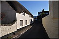
7
Thatched cottages, Church Steps, Minehead
Thatched cottages line Church Steps, a steep pathway connecting St Michael's Road adjacent to the church, with Vicarage Road and Church Street.
Image: © Jaggery
Taken: 21 Mar 2010
0.02 miles
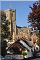
8
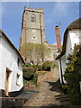
St Michael's Church tower, Minehead
Viewed from Church Steps. http://www.geograph.org.uk/photo/1766926
The tower dates from the 15th century. Other parts of the church may predate the tower by several decades.
Image: © Jaggery
Taken: 21 Mar 2010
0.02 miles
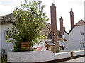
9
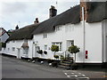
Pilgrim Corner, Vicarage Road, Minehead
Pilgrim Corner is a Grade II listed building, located at the foot of Church Steps.
http://www.geograph.org.uk/photo/1766926
En suite accommodation is available.
http://www.geograph.org.uk/photo/1766946 to a closeup of the Victorian postbox.
Image: © Jaggery
Taken: 21 Mar 2010
0.02 miles
10
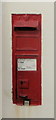
Wall postbox, Pilgrim Corner, Minehead
The postbox is located in the wall of the Grade II listed building Pilgrim Corner http://www.geograph.org.uk/photo/1766941 at the corner of Vicarage Road and Church Steps.
Image: © Jaggery
Taken: 21 Mar 2010
0.02 miles